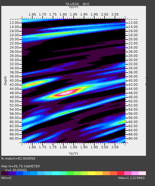
U52A Thorn Hill, TN, USA - Earthquake Result Viewer
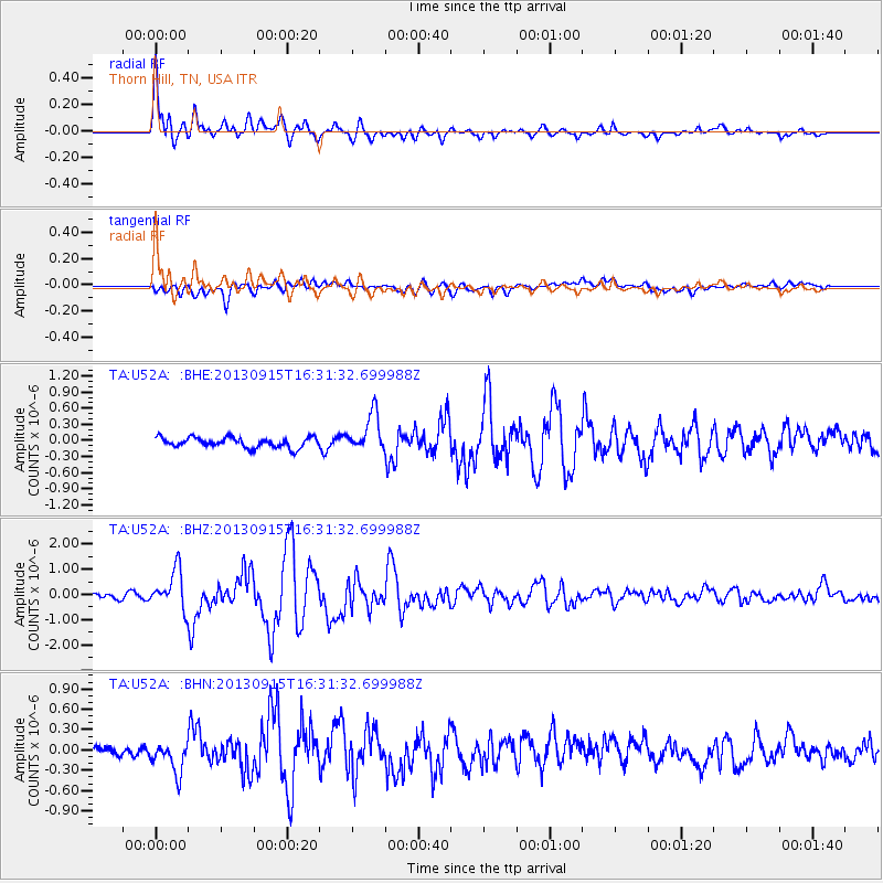
Earthquake location: Andreanof Islands, Aleutian Is.
Earthquake latitude/longitude: 51.6/-174.7
Earthquake time(UTC): 2013/09/15 (258) 16:21:37 GMT
Earthquake Depth: 24 km
Earthquake Magnitude: 6.1 MWW, 5.7 MI, 5.7 ML, 6.0 MWB, 6.1 MWC, 6.1 MWW
Earthquake Catalog/Contributor: NEIC PDE/NEIC COMCAT
Network: TA USArray Transportable Network (new EarthScope stations)
Station: U52A Thorn Hill, TN, USA
Lat/Lon: 36.39 N/83.37 W
Elevation: 510 m
Distance: 63.3 deg
Az: 64.573 deg
Baz: 315.693 deg
Ray Param: 0.05965237
Estimated Moho Depth: 45.75 km
Estimated Crust Vp/Vs: 1.81
Assumed Crust Vp: 6.476 km/s
Estimated Crust Vs: 3.578 km/s
Estimated Crust Poisson's Ratio: 0.28
Radial Match: 92.900955 %
Radial Bump: 400
Transverse Match: 75.257416 %
Transverse Bump: 400
SOD ConfigId: 626651
Insert Time: 2014-04-18 17:34:58.541 +0000
GWidth: 2.5
Max Bumps: 400
Tol: 0.001

Signal To Noise

ChannelStoNSTALTA
TA:U52A: :BHZ:20130915T16:31:32.699988Z8.6205017.7060565E-78.939222E-8
TA:U52A: :BHN:20130915T16:31:32.699988Z2.52862452.4409903E-79.653431E-8
TA:U52A: :BHE:20130915T16:31:32.699988Z3.80348183.5956876E-79.453674E-8
Arrivals
Ps6.0 SECOND
PpPs19 SECOND
PsPs/PpSs25 SECOND