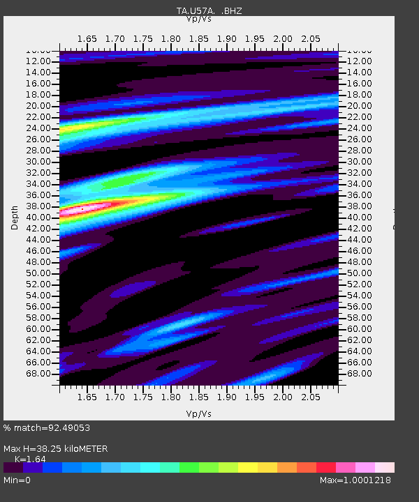
U57A Blanch, NC, USA - Earthquake Result Viewer

Earthquake location: Andreanof Islands, Aleutian Is.
Earthquake latitude/longitude: 51.6/-174.7
Earthquake time(UTC): 2013/09/15 (258) 16:21:37 GMT
Earthquake Depth: 24 km
Earthquake Magnitude: 6.1 MWW, 5.7 MI, 5.7 ML, 6.0 MWB, 6.1 MWC, 6.1 MWW
Earthquake Catalog/Contributor: NEIC PDE/NEIC COMCAT
Network: TA USArray Transportable Network (new EarthScope stations)
Station: U57A Blanch, NC, USA
Lat/Lon: 36.43 N/79.34 W
Elevation: 178 m
Distance: 65.5 deg
Az: 61.936 deg
Baz: 316.935 deg
Ray Param: 0.058206085
Estimated Moho Depth: 38.25 km
Estimated Crust Vp/Vs: 1.64
Assumed Crust Vp: 6.419 km/s
Estimated Crust Vs: 3.914 km/s
Estimated Crust Poisson's Ratio: 0.20
Radial Match: 92.49053 %
Radial Bump: 400
Transverse Match: 63.66334 %
Transverse Bump: 400
SOD ConfigId: 626651
Insert Time: 2014-04-18 17:35:18.914 +0000
GWidth: 2.5
Max Bumps: 400
Tol: 0.001

Signal To Noise

ChannelStoNSTALTA
TA:U57A: :BHZ:20130915T16:31:47.199988Z9.7747671.1325765E-61.15867365E-7
TA:U57A: :BHN:20130915T16:31:47.199988Z5.58508874.929272E-78.8257714E-8
TA:U57A: :BHE:20130915T16:31:47.199988Z2.794482.9683562E-71.0622214E-7
Arrivals
Ps4.0 SECOND
PpPs15 SECOND
PsPs/PpSs19 SECOND