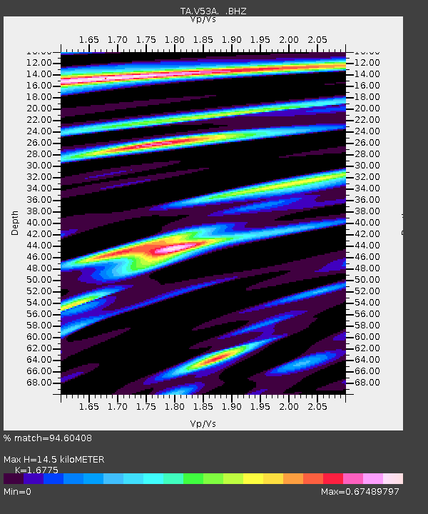
V53A Saluda, NC, USA - Earthquake Result Viewer

Earthquake location: Andreanof Islands, Aleutian Is.
Earthquake latitude/longitude: 51.6/-174.7
Earthquake time(UTC): 2013/09/15 (258) 16:21:37 GMT
Earthquake Depth: 24 km
Earthquake Magnitude: 6.1 MWW, 5.7 MI, 5.7 ML, 6.0 MWB, 6.1 MWC, 6.1 MWW
Earthquake Catalog/Contributor: NEIC PDE/NEIC COMCAT
Network: TA USArray Transportable Network (new EarthScope stations)
Station: V53A Saluda, NC, USA
Lat/Lon: 35.67 N/82.81 W
Elevation: 681 m
Distance: 64.1 deg
Az: 64.773 deg
Baz: 316.107 deg
Ray Param: 0.05910716
Estimated Moho Depth: 14.5 km
Estimated Crust Vp/Vs: 1.68
Assumed Crust Vp: 6.35 km/s
Estimated Crust Vs: 3.785 km/s
Estimated Crust Poisson's Ratio: 0.22
Radial Match: 94.60408 %
Radial Bump: 339
Transverse Match: 79.4236 %
Transverse Bump: 400
SOD ConfigId: 626651
Insert Time: 2014-04-18 17:35:47.262 +0000
GWidth: 2.5
Max Bumps: 400
Tol: 0.001

Signal To Noise

ChannelStoNSTALTA
TA:V53A: :BHZ:20130915T16:31:38.199988Z6.8100087.1972426E-71.05686254E-7
TA:V53A: :BHN:20130915T16:31:38.199988Z3.15874531.8766784E-75.9412148E-8
TA:V53A: :BHE:20130915T16:31:38.199988Z3.5460952.5568798E-77.21041E-8
Arrivals
Ps1.6 SECOND
PpPs5.8 SECOND
PsPs/PpSs7.5 SECOND