V57A Coltrane Farms, NC, USA - Earthquake Result Viewer
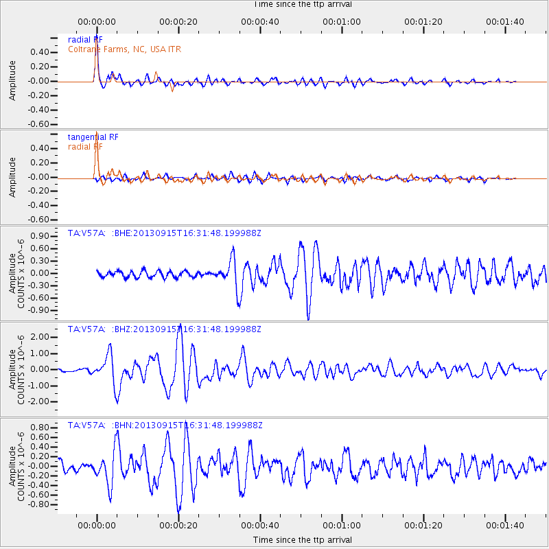
Earthquake location: Andreanof Islands, Aleutian Is.
Earthquake latitude/longitude: 51.6/-174.7
Earthquake time(UTC): 2013/09/15 (258) 16:21:37 GMT
Earthquake Depth: 24 km
Earthquake Magnitude: 6.1 MWW, 5.7 MI, 5.7 ML, 6.0 MWB, 6.1 MWC, 6.1 MWW
Earthquake Catalog/Contributor: NEIC PDE/NEIC COMCAT
Network: TA USArray Transportable Network (new EarthScope stations)
Station: V57A Coltrane Farms, NC, USA
Lat/Lon: 35.89 N/79.78 W
Elevation: 223 m
Distance: 65.6 deg
Az: 62.629 deg
Baz: 316.964 deg
Ray Param: 0.05810483
Estimated Moho Depth: 34.25 km
Estimated Crust Vp/Vs: 2.05
Assumed Crust Vp: 6.565 km/s
Estimated Crust Vs: 3.21 km/s
Estimated Crust Poisson's Ratio: 0.34
Radial Match: 93.55114 %
Radial Bump: 400
Transverse Match: 85.78039 %
Transverse Bump: 400
SOD ConfigId: 626651
Insert Time: 2014-04-18 17:36:02.789 +0000
GWidth: 2.5
Max Bumps: 400
Tol: 0.001

Signal To Noise

ChannelStoNSTALTA
TA:V57A: :BHZ:20130915T16:31:48.199988Z9.164178.9733567E-79.791783E-8
TA:V57A: :BHN:20130915T16:31:48.199988Z4.2028653.501405E-78.330996E-8
TA:V57A: :BHE:20130915T16:31:48.199988Z4.62756733.4086776E-77.3660246E-8
Arrivals
Ps5.7 SECOND
PpPs15 SECOND
PsPs/PpSs21 SECOND