W41B Gary Mavity, Velonia, AR, USA - Earthquake Result Viewer
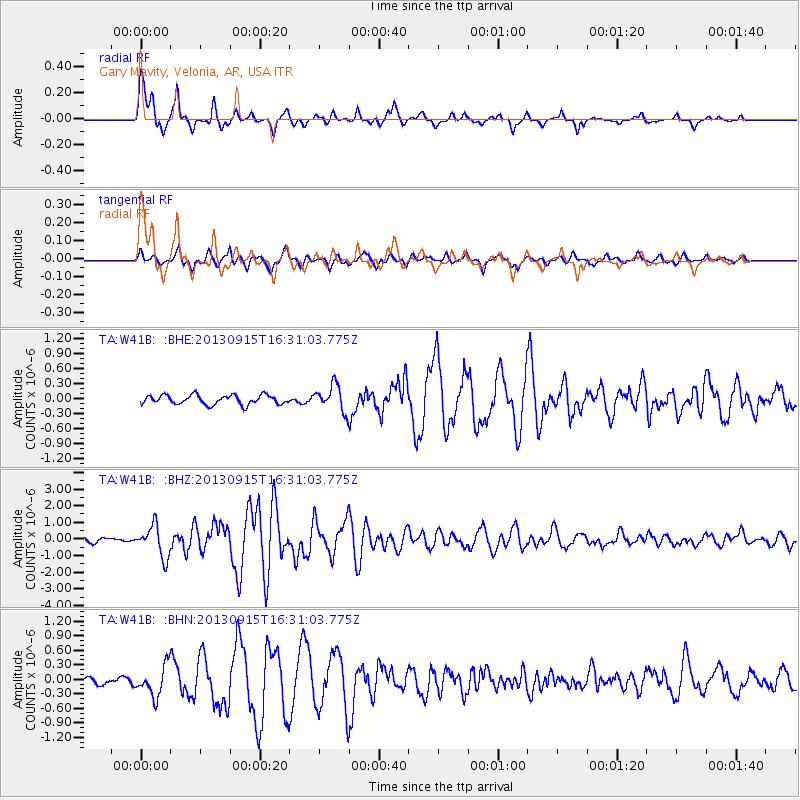
Earthquake location: Andreanof Islands, Aleutian Is.
Earthquake latitude/longitude: 51.6/-174.7
Earthquake time(UTC): 2013/09/15 (258) 16:21:37 GMT
Earthquake Depth: 24 km
Earthquake Magnitude: 6.1 MWW, 5.7 MI, 5.7 ML, 6.0 MWB, 6.1 MWC, 6.1 MWW
Earthquake Catalog/Contributor: NEIC PDE/NEIC COMCAT
Network: TA USArray Transportable Network (new EarthScope stations)
Station: W41B Gary Mavity, Velonia, AR, USA
Lat/Lon: 35.17 N/92.25 W
Elevation: 95 m
Distance: 59.0 deg
Az: 71.359 deg
Baz: 313.797 deg
Ray Param: 0.062447708
Estimated Moho Depth: 35.75 km
Estimated Crust Vp/Vs: 2.07
Assumed Crust Vp: 6.498 km/s
Estimated Crust Vs: 3.135 km/s
Estimated Crust Poisson's Ratio: 0.35
Radial Match: 92.67968 %
Radial Bump: 308
Transverse Match: 75.17677 %
Transverse Bump: 400
SOD ConfigId: 626651
Insert Time: 2014-04-18 17:36:24.836 +0000
GWidth: 2.5
Max Bumps: 400
Tol: 0.001

Signal To Noise

ChannelStoNSTALTA
TA:W41B: :BHZ:20130915T16:31:03.775Z4.90858849.5067315E-71.9367546E-7
TA:W41B: :BHN:20130915T16:31:03.775Z2.58776523.1434868E-71.2147497E-7
TA:W41B: :BHE:20130915T16:31:03.775Z2.84203122.6046726E-79.164828E-8
Arrivals
Ps6.2 SECOND
PpPs16 SECOND
PsPs/PpSs22 SECOND