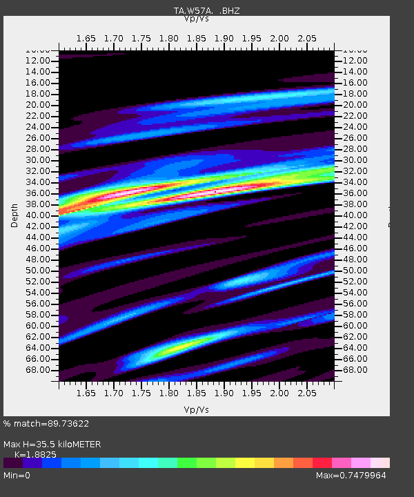
W57A Gilead, NC, USA - Earthquake Result Viewer

Earthquake location: Andreanof Islands, Aleutian Is.
Earthquake latitude/longitude: 51.6/-174.7
Earthquake time(UTC): 2013/09/15 (258) 16:21:37 GMT
Earthquake Depth: 24 km
Earthquake Magnitude: 6.1 MWW, 5.7 MI, 5.7 ML, 6.0 MWB, 6.1 MWC, 6.1 MWW
Earthquake Catalog/Contributor: NEIC PDE/NEIC COMCAT
Network: TA USArray Transportable Network (new EarthScope stations)
Station: W57A Gilead, NC, USA
Lat/Lon: 35.15 N/79.99 W
Elevation: 85 m
Distance: 66.1 deg
Az: 63.318 deg
Baz: 317.12 deg
Ray Param: 0.057832338
Estimated Moho Depth: 35.5 km
Estimated Crust Vp/Vs: 1.88
Assumed Crust Vp: 6.565 km/s
Estimated Crust Vs: 3.487 km/s
Estimated Crust Poisson's Ratio: 0.30
Radial Match: 89.73622 %
Radial Bump: 400
Transverse Match: 76.97118 %
Transverse Bump: 400
SOD ConfigId: 626651
Insert Time: 2014-04-18 17:36:50.568 +0000
GWidth: 2.5
Max Bumps: 400
Tol: 0.001

Signal To Noise

ChannelStoNSTALTA
TA:W57A: :BHZ:20130915T16:31:50.874976Z6.23609458.655191E-71.3879185E-7
TA:W57A: :BHN:20130915T16:31:50.874976Z1.98845663.226525E-71.6226278E-7
TA:W57A: :BHE:20130915T16:31:50.874976Z3.36765123.3940955E-71.0078525E-7
Arrivals
Ps5.0 SECOND
PpPs15 SECOND
PsPs/PpSs20 SECOND