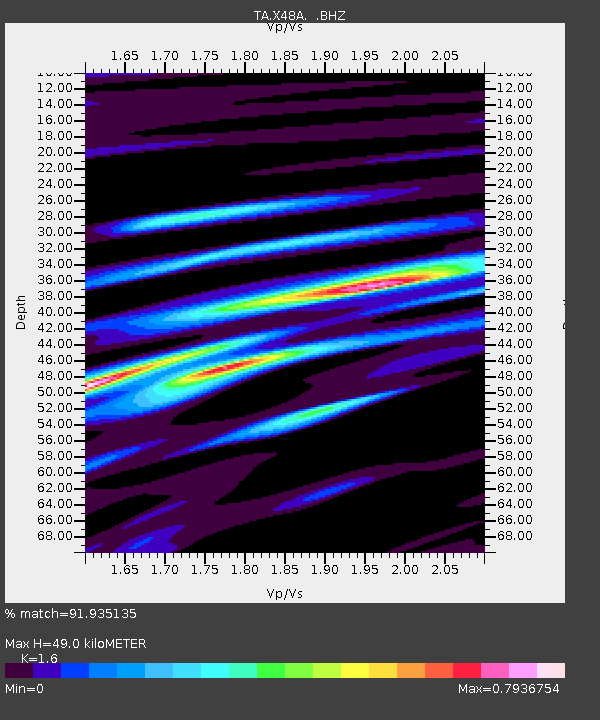
X48A Hartselle, AL, USA - Earthquake Result Viewer
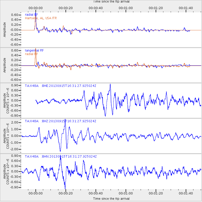
Earthquake location: Andreanof Islands, Aleutian Is.
Earthquake latitude/longitude: 51.6/-174.7
Earthquake time(UTC): 2013/09/15 (258) 16:21:37 GMT
Earthquake Depth: 24 km
Earthquake Magnitude: 6.1 MWW, 5.7 MI, 5.7 ML, 6.0 MWB, 6.1 MWC, 6.1 MWW
Earthquake Catalog/Contributor: NEIC PDE/NEIC COMCAT
Network: TA USArray Transportable Network (new EarthScope stations)
Station: X48A Hartselle, AL, USA
Lat/Lon: 34.45 N/87.05 W
Elevation: 180 m
Distance: 62.5 deg
Az: 68.504 deg
Baz: 315.361 deg
Ray Param: 0.06012042
Estimated Moho Depth: 49.0 km
Estimated Crust Vp/Vs: 1.60
Assumed Crust Vp: 6.476 km/s
Estimated Crust Vs: 4.047 km/s
Estimated Crust Poisson's Ratio: 0.18
Radial Match: 91.935135 %
Radial Bump: 378
Transverse Match: 75.3344 %
Transverse Bump: 400
SOD ConfigId: 626651
Insert Time: 2014-04-18 17:37:30.219 +0000
GWidth: 2.5
Max Bumps: 400
Tol: 0.001

Signal To Noise

ChannelStoNSTALTA
TA:X48A: :BHZ:20130915T16:31:27.925024Z6.8035486.6949985E-79.840452E-8
TA:X48A: :BHN:20130915T16:31:27.925024Z2.89442752.4885063E-78.597577E-8
TA:X48A: :BHE:20130915T16:31:27.925024Z4.27068662.9841092E-76.9874226E-8
Arrivals
Ps4.8 SECOND
PpPs19 SECOND
PsPs/PpSs23 SECOND