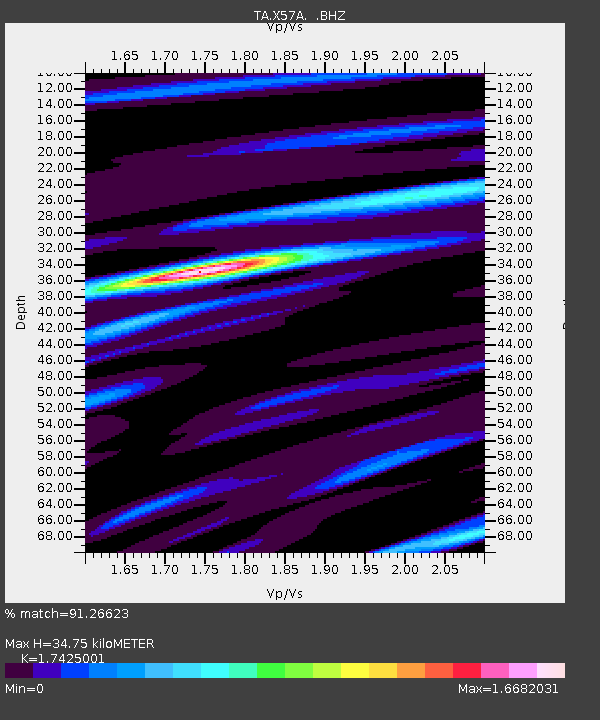
X57A Johnson Farm, Hartsville, SC, USA - Earthquake Result Viewer
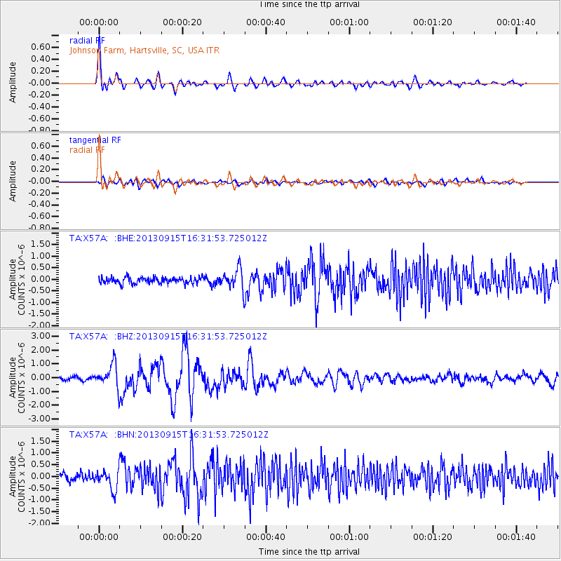
Earthquake location: Andreanof Islands, Aleutian Is.
Earthquake latitude/longitude: 51.6/-174.7
Earthquake time(UTC): 2013/09/15 (258) 16:21:37 GMT
Earthquake Depth: 24 km
Earthquake Magnitude: 6.1 MWW, 5.7 MI, 5.7 ML, 6.0 MWB, 6.1 MWC, 6.1 MWW
Earthquake Catalog/Contributor: NEIC PDE/NEIC COMCAT
Network: TA USArray Transportable Network (new EarthScope stations)
Station: X57A Johnson Farm, Hartsville, SC, USA
Lat/Lon: 34.46 N/80.09 W
Elevation: 133 m
Distance: 66.5 deg
Az: 63.894 deg
Baz: 317.294 deg
Ray Param: 0.057539005
Estimated Moho Depth: 34.75 km
Estimated Crust Vp/Vs: 1.74
Assumed Crust Vp: 6.419 km/s
Estimated Crust Vs: 3.684 km/s
Estimated Crust Poisson's Ratio: 0.25
Radial Match: 91.26623 %
Radial Bump: 400
Transverse Match: 73.93227 %
Transverse Bump: 400
SOD ConfigId: 626651
Insert Time: 2014-04-18 17:37:58.622 +0000
GWidth: 2.5
Max Bumps: 400
Tol: 0.001

Signal To Noise

ChannelStoNSTALTA
TA:X57A: :BHZ:20130915T16:31:53.725012Z6.36673648.653588E-71.3591874E-7
TA:X57A: :BHN:20130915T16:31:53.725012Z2.76882864.2022873E-71.517713E-7
TA:X57A: :BHE:20130915T16:31:53.725012Z3.46552784.4974783E-71.2977759E-7
Arrivals
Ps4.2 SECOND
PpPs14 SECOND
PsPs/PpSs18 SECOND