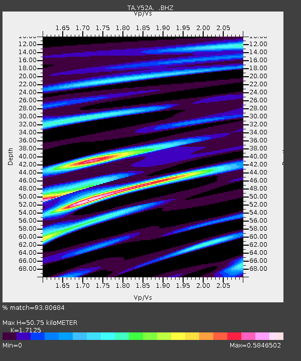
Y52A Lilburn, GA, USA - Earthquake Result Viewer
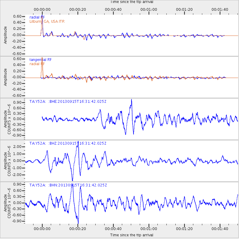
Earthquake location: Andreanof Islands, Aleutian Is.
Earthquake latitude/longitude: 51.6/-174.7
Earthquake time(UTC): 2013/09/15 (258) 16:21:37 GMT
Earthquake Depth: 24 km
Earthquake Magnitude: 6.1 MWW, 5.7 MI, 5.7 ML, 6.0 MWB, 6.1 MWC, 6.1 MWW
Earthquake Catalog/Contributor: NEIC PDE/NEIC COMCAT
Network: TA USArray Transportable Network (new EarthScope stations)
Station: Y52A Lilburn, GA, USA
Lat/Lon: 33.86 N/84.06 W
Elevation: 286 m
Distance: 64.7 deg
Az: 66.979 deg
Baz: 316.35 deg
Ray Param: 0.058728185
Estimated Moho Depth: 50.75 km
Estimated Crust Vp/Vs: 1.71
Assumed Crust Vp: 6.719 km/s
Estimated Crust Vs: 3.924 km/s
Estimated Crust Poisson's Ratio: 0.24
Radial Match: 93.80684 %
Radial Bump: 334
Transverse Match: 71.35373 %
Transverse Bump: 400
SOD ConfigId: 626651
Insert Time: 2014-04-18 17:38:18.547 +0000
GWidth: 2.5
Max Bumps: 400
Tol: 0.001

Signal To Noise

ChannelStoNSTALTA
TA:Y52A: :BHZ:20130915T16:31:42.025Z7.99363958.14551E-71.0189989E-7
TA:Y52A: :BHN:20130915T16:31:42.025Z2.78215742.5802024E-79.2741054E-8
TA:Y52A: :BHE:20130915T16:31:42.025Z4.4751932.8112058E-76.2817534E-8
Arrivals
Ps5.6 SECOND
PpPs20 SECOND
PsPs/PpSs25 SECOND