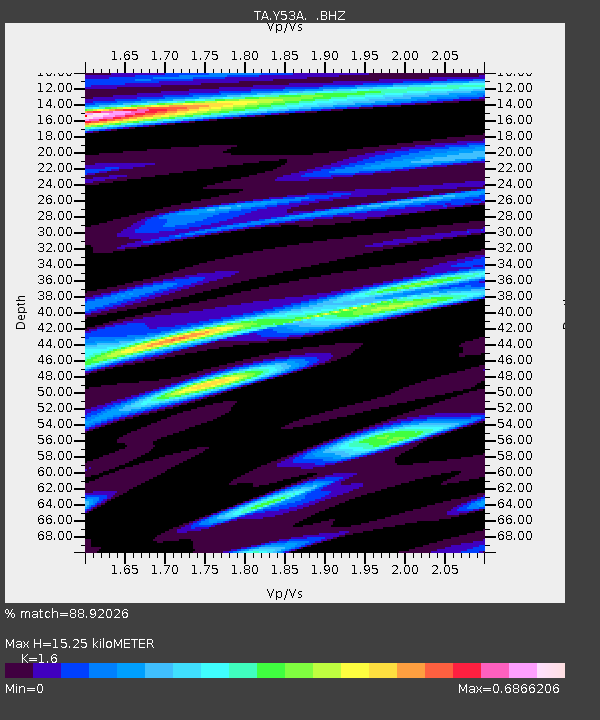
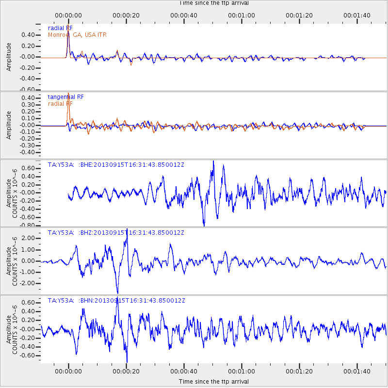
Y53A Monroe, GA, USA - Earthquake Result Viewer

Earthquake location: Andreanof Islands, Aleutian Is.
Earthquake latitude/longitude: 51.6/-174.7
Earthquake time(UTC): 2013/09/15 (258) 16:21:37 GMT
Earthquake Depth: 24 km
Earthquake Magnitude: 6.1 MWW, 5.7 MI, 5.7 ML, 6.0 MWB, 6.1 MWC, 6.1 MWW
Earthquake Catalog/Contributor: NEIC PDE/NEIC COMCAT
Network: TA USArray Transportable Network (new EarthScope stations)
Station: Y53A Monroe, GA, USA
Lat/Lon: 33.86 N/83.58 W
Elevation: 234 m
Distance: 65.0 deg
Az: 66.666 deg
Baz: 316.483 deg
Ray Param: 0.058545396
Estimated Moho Depth: 15.25 km
Estimated Crust Vp/Vs: 1.60
Assumed Crust Vp: 6.565 km/s
Estimated Crust Vs: 4.103 km/s
Estimated Crust Poisson's Ratio: 0.18
Radial Match: 88.92026 %
Radial Bump: 400
Transverse Match: 73.300476 %
Transverse Bump: 400
SOD ConfigId: 626651
Insert Time: 2014-04-18 17:38:20.710 +0000
GWidth: 2.5
Max Bumps: 400
Tol: 0.001

Signal To Noise

ChannelStoNSTALTA
TA:Y53A: :BHZ:20130915T16:31:43.850012Z7.86178546.904854E-78.782807E-8
TA:Y53A: :BHN:20130915T16:31:43.850012Z2.80896932.3987886E-78.539747E-8
TA:Y53A: :BHE:20130915T16:31:43.850012Z2.76525782.214365E-78.007807E-8
Arrivals
Ps1.5 SECOND
PpPs5.8 SECOND
PsPs/PpSs7.2 SECOND