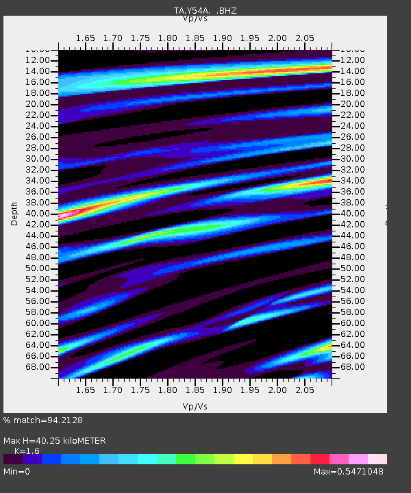
Y54A Tignall, GA, USA - Earthquake Result Viewer
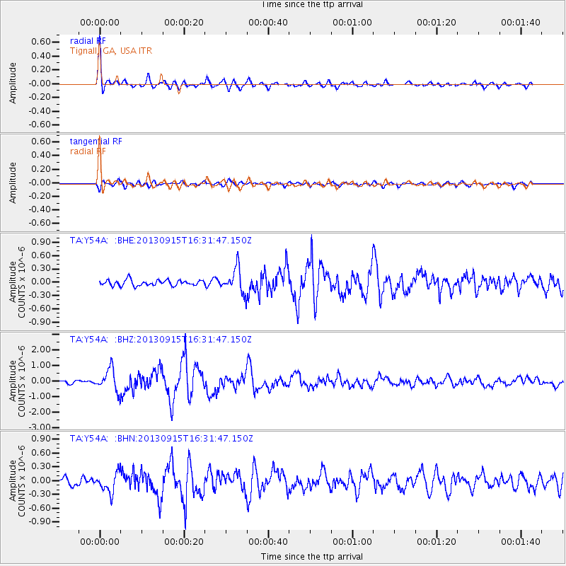
Earthquake location: Andreanof Islands, Aleutian Is.
Earthquake latitude/longitude: 51.6/-174.7
Earthquake time(UTC): 2013/09/15 (258) 16:21:37 GMT
Earthquake Depth: 24 km
Earthquake Magnitude: 6.1 MWW, 5.7 MI, 5.7 ML, 6.0 MWB, 6.1 MWC, 6.1 MWW
Earthquake Catalog/Contributor: NEIC PDE/NEIC COMCAT
Network: TA USArray Transportable Network (new EarthScope stations)
Station: Y54A Tignall, GA, USA
Lat/Lon: 33.86 N/82.69 W
Elevation: 176 m
Distance: 65.5 deg
Az: 66.065 deg
Baz: 316.727 deg
Ray Param: 0.05821251
Estimated Moho Depth: 40.25 km
Estimated Crust Vp/Vs: 1.60
Assumed Crust Vp: 6.565 km/s
Estimated Crust Vs: 4.103 km/s
Estimated Crust Poisson's Ratio: 0.18
Radial Match: 94.2128 %
Radial Bump: 400
Transverse Match: 74.14029 %
Transverse Bump: 400
SOD ConfigId: 626651
Insert Time: 2014-04-18 17:38:23.253 +0000
GWidth: 2.5
Max Bumps: 400
Tol: 0.001

Signal To Noise

ChannelStoNSTALTA
TA:Y54A: :BHZ:20130915T16:31:47.150Z7.94725667.3602826E-79.261413E-8
TA:Y54A: :BHN:20130915T16:31:47.150Z2.9159742.1986476E-77.540011E-8
TA:Y54A: :BHE:20130915T16:31:47.150Z4.63522962.9186805E-76.296733E-8
Arrivals
Ps3.9 SECOND
PpPs15 SECOND
PsPs/PpSs19 SECOND