Y56A Pelion, SC, USA - Earthquake Result Viewer
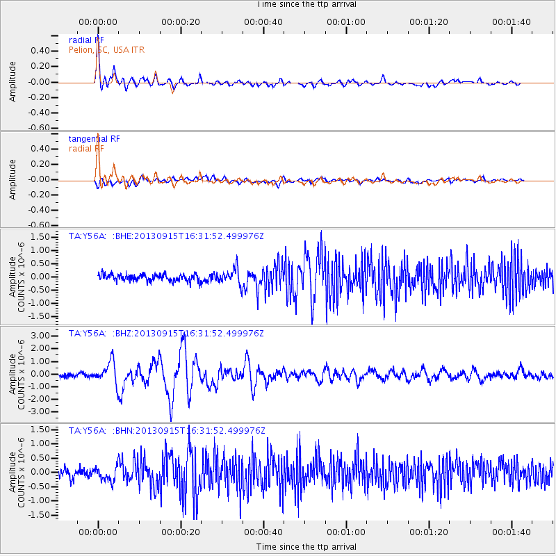
Earthquake location: Andreanof Islands, Aleutian Is.
Earthquake latitude/longitude: 51.6/-174.7
Earthquake time(UTC): 2013/09/15 (258) 16:21:37 GMT
Earthquake Depth: 24 km
Earthquake Magnitude: 6.1 MWW, 5.7 MI, 5.7 ML, 6.0 MWB, 6.1 MWC, 6.1 MWW
Earthquake Catalog/Contributor: NEIC PDE/NEIC COMCAT
Network: TA USArray Transportable Network (new EarthScope stations)
Station: Y56A Pelion, SC, USA
Lat/Lon: 33.79 N/81.30 W
Elevation: 154 m
Distance: 66.3 deg
Az: 65.196 deg
Baz: 317.139 deg
Ray Param: 0.057664055
Estimated Moho Depth: 36.0 km
Estimated Crust Vp/Vs: 1.72
Assumed Crust Vp: 6.565 km/s
Estimated Crust Vs: 3.817 km/s
Estimated Crust Poisson's Ratio: 0.24
Radial Match: 89.25948 %
Radial Bump: 400
Transverse Match: 62.40689 %
Transverse Bump: 400
SOD ConfigId: 626651
Insert Time: 2014-04-18 17:38:28.464 +0000
GWidth: 2.5
Max Bumps: 400
Tol: 0.001

Signal To Noise

ChannelStoNSTALTA
TA:Y56A: :BHZ:20130915T16:31:52.499976Z6.552958.933179E-71.3632302E-7
TA:Y56A: :BHN:20130915T16:31:52.499976Z1.45367562.7837262E-71.9149569E-7
TA:Y56A: :BHE:20130915T16:31:52.499976Z2.39059263.0468814E-71.2745299E-7
Arrivals
Ps4.1 SECOND
PpPs14 SECOND
PsPs/PpSs18 SECOND