Z56A Williston, SC, USA - Earthquake Result Viewer
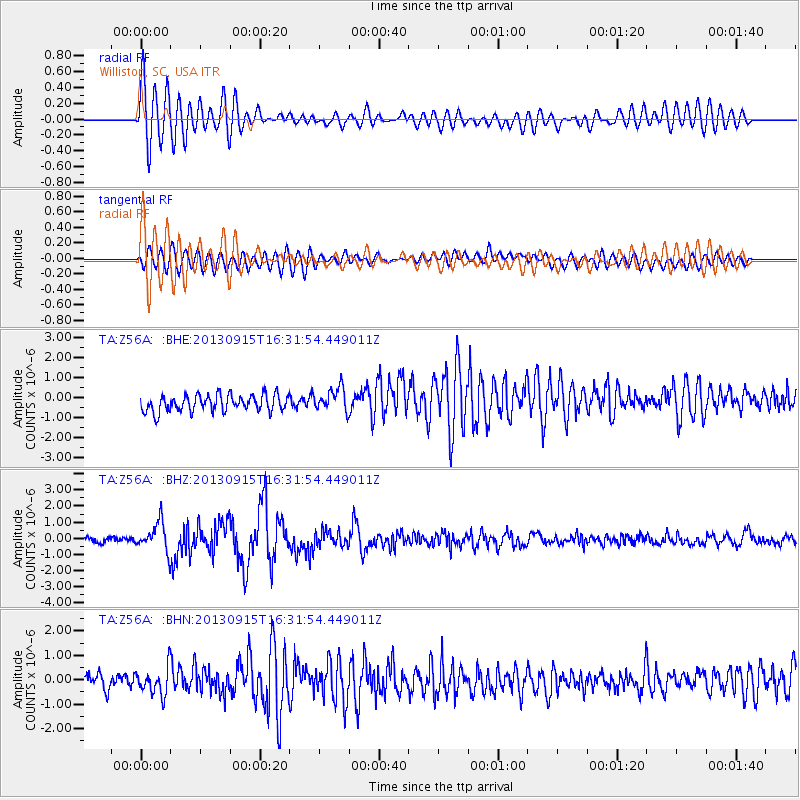
Earthquake location: Andreanof Islands, Aleutian Is.
Earthquake latitude/longitude: 51.6/-174.7
Earthquake time(UTC): 2013/09/15 (258) 16:21:37 GMT
Earthquake Depth: 24 km
Earthquake Magnitude: 6.1 MWW, 5.7 MI, 5.7 ML, 6.0 MWB, 6.1 MWC, 6.1 MWW
Earthquake Catalog/Contributor: NEIC PDE/NEIC COMCAT
Network: TA USArray Transportable Network (new EarthScope stations)
Station: Z56A Williston, SC, USA
Lat/Lon: 33.33 N/81.37 W
Elevation: 81 m
Distance: 66.6 deg
Az: 65.583 deg
Baz: 317.258 deg
Ray Param: 0.057462256
Estimated Moho Depth: 33.75 km
Estimated Crust Vp/Vs: 1.85
Assumed Crust Vp: 6.565 km/s
Estimated Crust Vs: 3.548 km/s
Estimated Crust Poisson's Ratio: 0.29
Radial Match: 86.24489 %
Radial Bump: 400
Transverse Match: 61.860966 %
Transverse Bump: 400
SOD ConfigId: 626651
Insert Time: 2014-04-18 17:39:01.332 +0000
GWidth: 2.5
Max Bumps: 400
Tol: 0.001

Signal To Noise

ChannelStoNSTALTA
TA:Z56A: :BHZ:20130915T16:31:54.449011Z6.06056558.851937E-71.4605793E-7
TA:Z56A: :BHN:20130915T16:31:54.449011Z2.03627065.428945E-72.6661215E-7
TA:Z56A: :BHE:20130915T16:31:54.449011Z1.44831625.9205047E-74.0878535E-7
Arrivals
Ps4.6 SECOND
PpPs14 SECOND
PsPs/PpSs19 SECOND