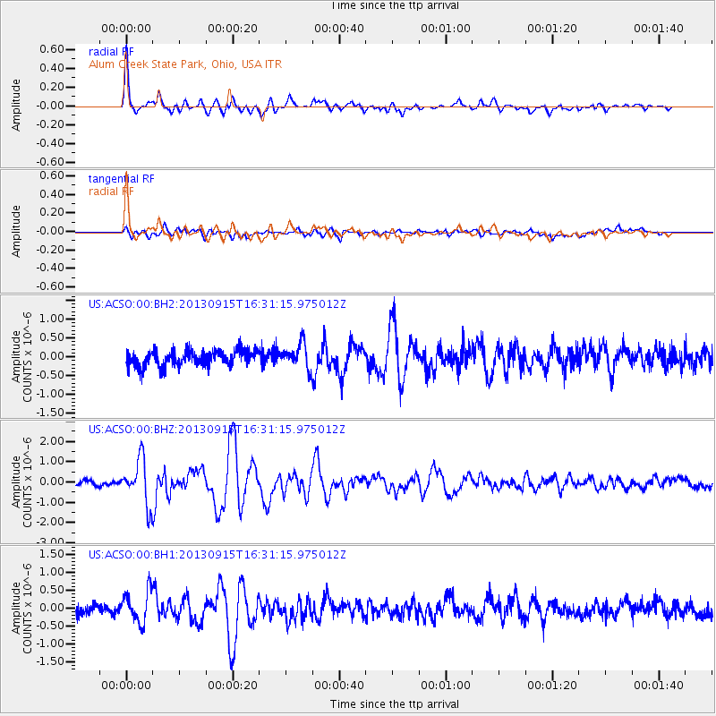
ACSO Alum Creek State Park, Ohio, USA - Earthquake Result Viewer
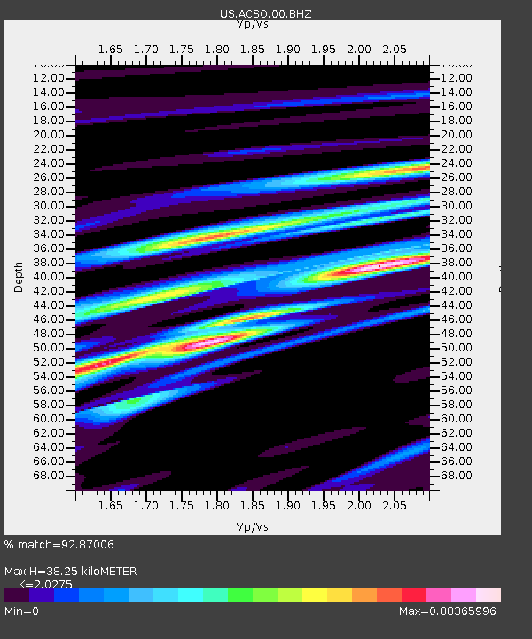
Earthquake location: Andreanof Islands, Aleutian Is.
Earthquake latitude/longitude: 51.6/-174.7
Earthquake time(UTC): 2013/09/15 (258) 16:21:37 GMT
Earthquake Depth: 24 km
Earthquake Magnitude: 6.1 MWW, 5.7 MI, 5.7 ML, 6.0 MWB, 6.1 MWC, 6.1 MWW
Earthquake Catalog/Contributor: NEIC PDE/NEIC COMCAT
Network: US United States National Seismic Network
Station: ACSO Alum Creek State Park, Ohio, USA
Lat/Lon: 40.23 N/82.98 W
Elevation: 288 m
Distance: 60.8 deg
Az: 61.263 deg
Baz: 314.377 deg
Ray Param: 0.061276887
Estimated Moho Depth: 38.25 km
Estimated Crust Vp/Vs: 2.03
Assumed Crust Vp: 6.498 km/s
Estimated Crust Vs: 3.205 km/s
Estimated Crust Poisson's Ratio: 0.34
Radial Match: 92.87006 %
Radial Bump: 400
Transverse Match: 69.211105 %
Transverse Bump: 400
SOD ConfigId: 626651
Insert Time: 2014-04-18 17:40:10.313 +0000
GWidth: 2.5
Max Bumps: 400
Tol: 0.001

Signal To Noise

ChannelStoNSTALTA
US:ACSO:00:BHZ:20130915T16:31:15.975012Z10.5317311.1223265E-61.065662E-7
US:ACSO:00:BH1:20130915T16:31:15.975012Z3.36598444.5416465E-71.3492773E-7
US:ACSO:00:BH2:20130915T16:31:15.975012Z1.56187183.3001942E-72.1129738E-7
Arrivals
Ps6.3 SECOND
PpPs17 SECOND
PsPs/PpSs23 SECOND