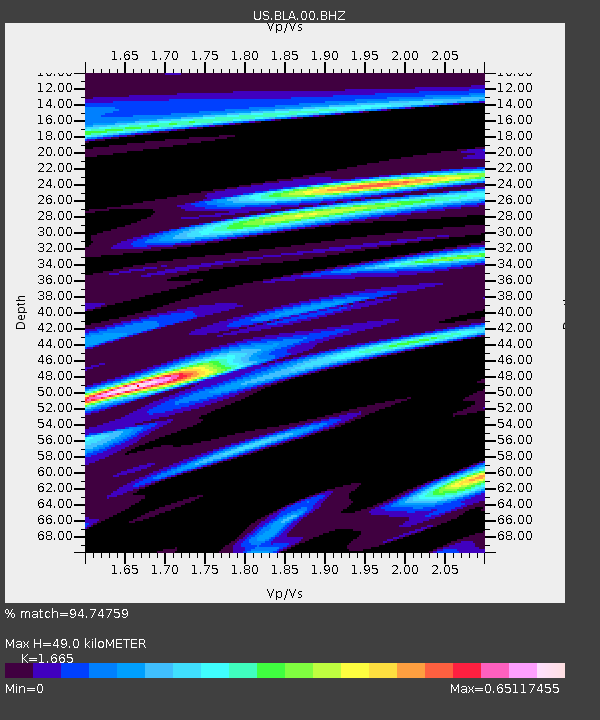
BLA Blacksburg, Virginia, USA - Earthquake Result Viewer
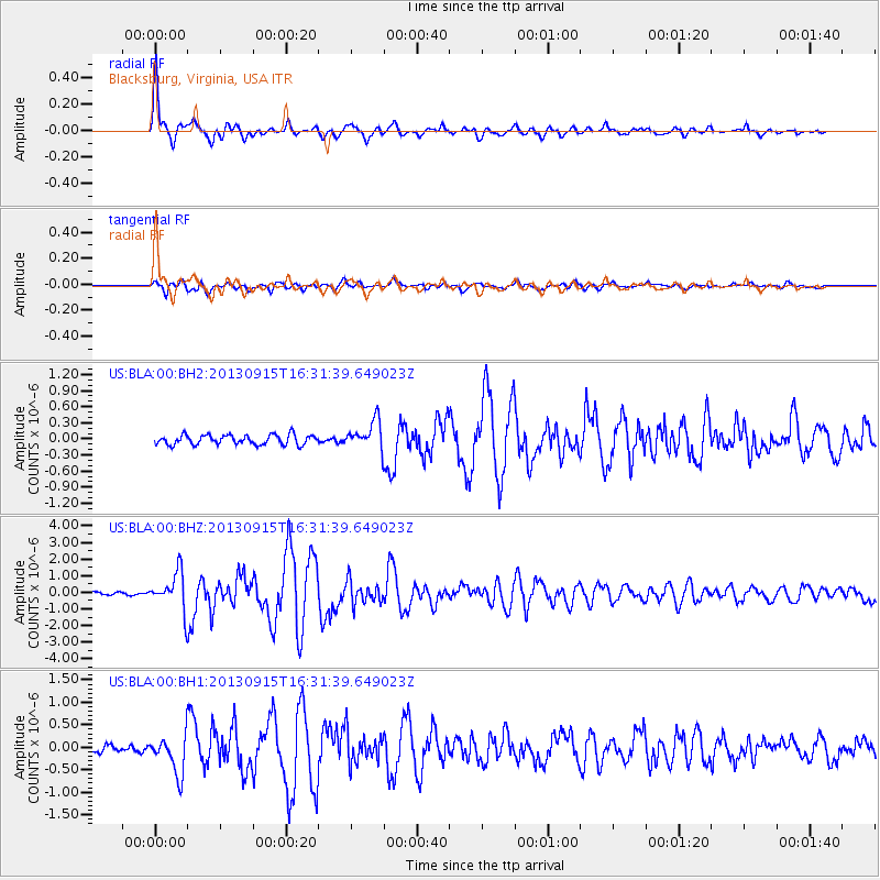
Earthquake location: Andreanof Islands, Aleutian Is.
Earthquake latitude/longitude: 51.6/-174.7
Earthquake time(UTC): 2013/09/15 (258) 16:21:37 GMT
Earthquake Depth: 24 km
Earthquake Magnitude: 6.1 MWW, 5.7 MI, 5.7 ML, 6.0 MWB, 6.1 MWC, 6.1 MWW
Earthquake Catalog/Contributor: NEIC PDE/NEIC COMCAT
Network: US United States National Seismic Network
Station: BLA Blacksburg, Virginia, USA
Lat/Lon: 37.21 N/80.42 W
Elevation: 634 m
Distance: 64.3 deg
Az: 62.045 deg
Baz: 316.334 deg
Ray Param: 0.05896176
Estimated Moho Depth: 49.0 km
Estimated Crust Vp/Vs: 1.66
Assumed Crust Vp: 6.159 km/s
Estimated Crust Vs: 3.699 km/s
Estimated Crust Poisson's Ratio: 0.22
Radial Match: 94.74759 %
Radial Bump: 400
Transverse Match: 84.11989 %
Transverse Bump: 400
SOD ConfigId: 626651
Insert Time: 2014-04-18 17:40:35.652 +0000
GWidth: 2.5
Max Bumps: 400
Tol: 0.001

Signal To Noise

ChannelStoNSTALTA
US:BLA:00:BHZ:20130915T16:31:39.649023Z8.6643691.1242175E-61.2975183E-7
US:BLA:00:BH1:20130915T16:31:39.649023Z3.56284764.1908416E-71.17626186E-7
US:BLA:00:BH2:20130915T16:31:39.649023Z2.85002162.610289E-79.15884E-8
Arrivals
Ps5.5 SECOND
PpPs20 SECOND
PsPs/PpSs26 SECOND