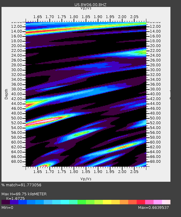
BW06 Boulder Array Site 6 (Pinedale), Wyoming, USA - Earthquake Result Viewer

Earthquake location: Andreanof Islands, Aleutian Is.
Earthquake latitude/longitude: 51.6/-174.7
Earthquake time(UTC): 2013/09/15 (258) 16:21:37 GMT
Earthquake Depth: 24 km
Earthquake Magnitude: 6.1 MWW, 5.7 MI, 5.7 ML, 6.0 MWB, 6.1 MWC, 6.1 MWW
Earthquake Catalog/Contributor: NEIC PDE/NEIC COMCAT
Network: US United States National Seismic Network
Station: BW06 Boulder Array Site 6 (Pinedale), Wyoming, USA
Lat/Lon: 42.77 N/109.56 W
Elevation: 2224 m
Distance: 43.8 deg
Az: 74.888 deg
Baz: 305.102 deg
Ray Param: 0.07227442
Estimated Moho Depth: 69.75 km
Estimated Crust Vp/Vs: 1.67
Assumed Crust Vp: 6.161 km/s
Estimated Crust Vs: 3.684 km/s
Estimated Crust Poisson's Ratio: 0.22
Radial Match: 91.773056 %
Radial Bump: 400
Transverse Match: 89.69508 %
Transverse Bump: 400
SOD ConfigId: 626651
Insert Time: 2014-04-18 17:40:41.792 +0000
GWidth: 2.5
Max Bumps: 400
Tol: 0.001

Signal To Noise

ChannelStoNSTALTA
US:BW06:00:BHZ:20130915T16:29:10.225012Z6.05856944.4163073E-77.289356E-8
US:BW06:00:BHN:20130915T16:29:10.225012Z1.8660691.4931767E-78.001723E-8
US:BW06:00:BHE:20130915T16:29:10.225012Z2.39937071.3682653E-75.7026007E-8
Arrivals
Ps8.1 SECOND
PpPs28 SECOND
PsPs/PpSs37 SECOND