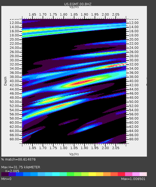
EGMT Eagleton, Montana, USA - Earthquake Result Viewer
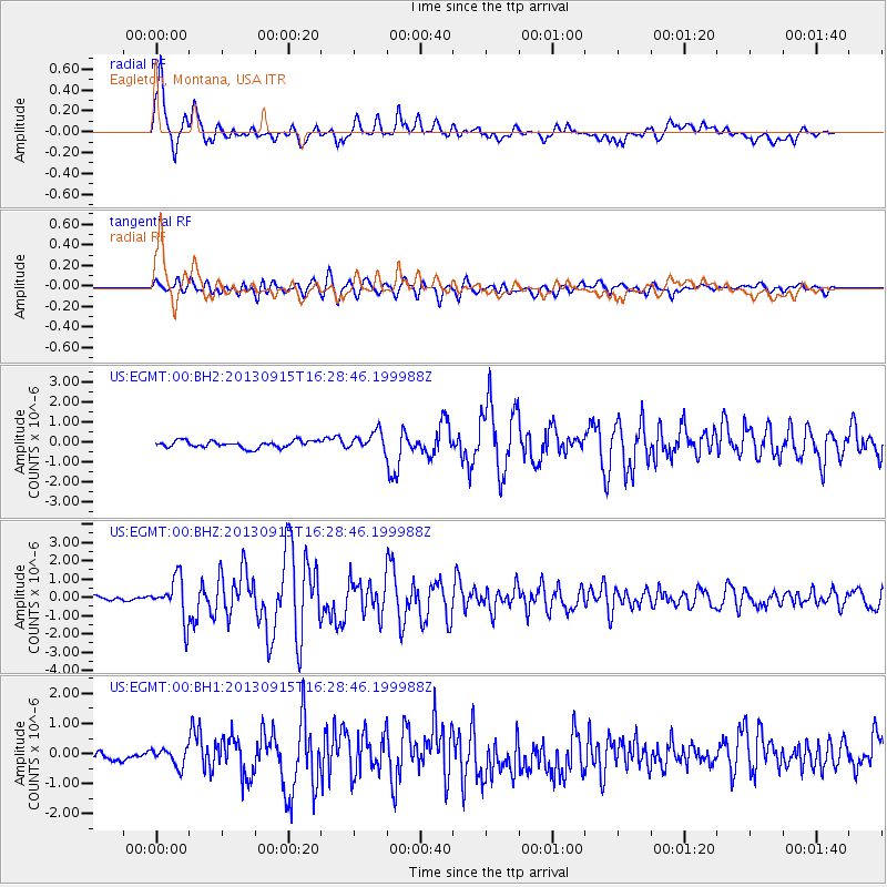
Earthquake location: Andreanof Islands, Aleutian Is.
Earthquake latitude/longitude: 51.6/-174.7
Earthquake time(UTC): 2013/09/15 (258) 16:21:37 GMT
Earthquake Depth: 24 km
Earthquake Magnitude: 6.1 MWW, 5.7 MI, 5.7 ML, 6.0 MWB, 6.1 MWC, 6.1 MWW
Earthquake Catalog/Contributor: NEIC PDE/NEIC COMCAT
Network: US United States National Seismic Network
Station: EGMT Eagleton, Montana, USA
Lat/Lon: 48.02 N/109.75 W
Elevation: 1055 m
Distance: 40.8 deg
Az: 68.422 deg
Baz: 300.178 deg
Ray Param: 0.07412014
Estimated Moho Depth: 31.75 km
Estimated Crust Vp/Vs: 2.09
Assumed Crust Vp: 6.438 km/s
Estimated Crust Vs: 3.088 km/s
Estimated Crust Poisson's Ratio: 0.35
Radial Match: 88.614876 %
Radial Bump: 400
Transverse Match: 76.525826 %
Transverse Bump: 400
SOD ConfigId: 626651
Insert Time: 2014-04-18 17:41:06.790 +0000
GWidth: 2.5
Max Bumps: 400
Tol: 0.001

Signal To Noise

ChannelStoNSTALTA
US:EGMT:00:BHZ:20130915T16:28:46.199988Z10.3631841.1345628E-61.0948014E-7
US:EGMT:00:BH1:20130915T16:28:46.199988Z1.45865313.1077647E-72.1305715E-7
US:EGMT:00:BH2:20130915T16:28:46.199988Z2.668884.670169E-71.749861E-7
Arrivals
Ps5.7 SECOND
PpPs14 SECOND
PsPs/PpSs20 SECOND