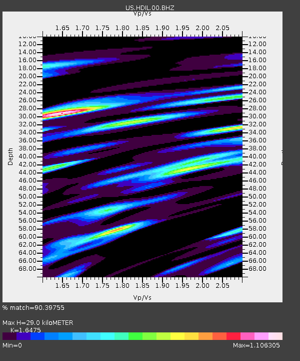
HDIL Hopedale, Illinois, USA - Earthquake Result Viewer
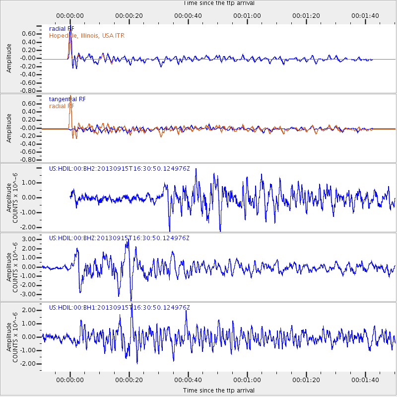
Earthquake location: Andreanof Islands, Aleutian Is.
Earthquake latitude/longitude: 51.6/-174.7
Earthquake time(UTC): 2013/09/15 (258) 16:21:37 GMT
Earthquake Depth: 24 km
Earthquake Magnitude: 6.1 MWW, 5.7 MI, 5.7 ML, 6.0 MWB, 6.1 MWC, 6.1 MWW
Earthquake Catalog/Contributor: NEIC PDE/NEIC COMCAT
Network: US United States National Seismic Network
Station: HDIL Hopedale, Illinois, USA
Lat/Lon: 40.56 N/89.29 W
Elevation: 219 m
Distance: 57.0 deg
Az: 64.845 deg
Baz: 312.152 deg
Ray Param: 0.063711524
Estimated Moho Depth: 29.0 km
Estimated Crust Vp/Vs: 1.65
Assumed Crust Vp: 6.498 km/s
Estimated Crust Vs: 3.944 km/s
Estimated Crust Poisson's Ratio: 0.21
Radial Match: 90.39755 %
Radial Bump: 400
Transverse Match: 67.30172 %
Transverse Bump: 400
SOD ConfigId: 626651
Insert Time: 2014-04-18 17:41:26.018 +0000
GWidth: 2.5
Max Bumps: 400
Tol: 0.001

Signal To Noise

ChannelStoNSTALTA
US:HDIL:00:BHZ:20130915T16:30:50.124976Z7.6201741.3037176E-61.7108765E-7
US:HDIL:00:BH1:20130915T16:30:50.124976Z2.7216254.9686724E-71.825627E-7
US:HDIL:00:BH2:20130915T16:30:50.124976Z4.1576937.291128E-71.7536475E-7
Arrivals
Ps3.1 SECOND
PpPs11 SECOND
PsPs/PpSs14 SECOND