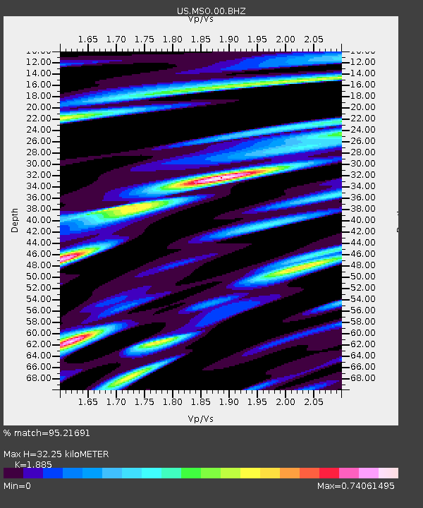
MSO Missoula, Montana, USA - Earthquake Result Viewer
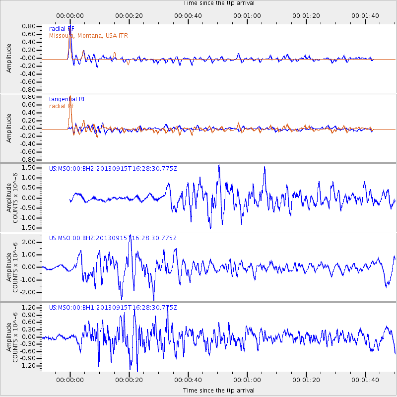
Earthquake location: Andreanof Islands, Aleutian Is.
Earthquake latitude/longitude: 51.6/-174.7
Earthquake time(UTC): 2013/09/15 (258) 16:21:37 GMT
Earthquake Depth: 24 km
Earthquake Magnitude: 6.1 MWW, 5.7 MI, 5.7 ML, 6.0 MWB, 6.1 MWC, 6.1 MWW
Earthquake Catalog/Contributor: NEIC PDE/NEIC COMCAT
Network: US United States National Seismic Network
Station: MSO Missoula, Montana, USA
Lat/Lon: 46.83 N/113.94 W
Elevation: 1264 m
Distance: 39.0 deg
Az: 72.255 deg
Baz: 300.045 deg
Ray Param: 0.075207345
Estimated Moho Depth: 32.25 km
Estimated Crust Vp/Vs: 1.88
Assumed Crust Vp: 6.353 km/s
Estimated Crust Vs: 3.37 km/s
Estimated Crust Poisson's Ratio: 0.30
Radial Match: 95.21691 %
Radial Bump: 400
Transverse Match: 72.45351 %
Transverse Bump: 400
SOD ConfigId: 626651
Insert Time: 2014-04-18 17:42:08.343 +0000
GWidth: 2.5
Max Bumps: 400
Tol: 0.001

Signal To Noise

ChannelStoNSTALTA
US:MSO:00:BHZ:20130915T16:28:30.775Z7.32452636.322351E-78.631754E-8
US:MSO:00:BH1:20130915T16:28:30.775Z2.08145281.9701422E-79.4652265E-8
US:MSO:00:BH2:20130915T16:28:30.775Z3.55564433.7402702E-71.0519248E-7
Arrivals
Ps4.8 SECOND
PpPs14 SECOND
PsPs/PpSs19 SECOND