TZTN Tazewell, Tennessee, USA - Earthquake Result Viewer
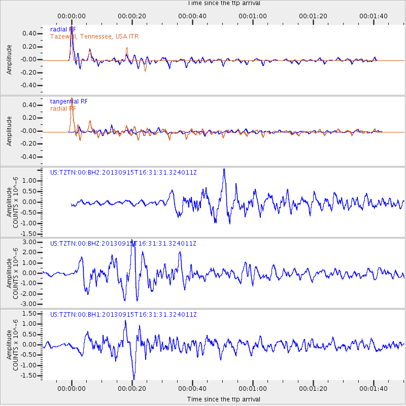
Earthquake location: Andreanof Islands, Aleutian Is.
Earthquake latitude/longitude: 51.6/-174.7
Earthquake time(UTC): 2013/09/15 (258) 16:21:37 GMT
Earthquake Depth: 24 km
Earthquake Magnitude: 6.1 MWW, 5.7 MI, 5.7 ML, 6.0 MWB, 6.1 MWC, 6.1 MWW
Earthquake Catalog/Contributor: NEIC PDE/NEIC COMCAT
Network: US United States National Seismic Network
Station: TZTN Tazewell, Tennessee, USA
Lat/Lon: 36.54 N/83.55 W
Elevation: 394 m
Distance: 63.1 deg
Az: 64.572 deg
Baz: 315.585 deg
Ray Param: 0.059788436
Estimated Moho Depth: 42.5 km
Estimated Crust Vp/Vs: 1.89
Assumed Crust Vp: 6.476 km/s
Estimated Crust Vs: 3.426 km/s
Estimated Crust Poisson's Ratio: 0.31
Radial Match: 95.56582 %
Radial Bump: 400
Transverse Match: 86.181625 %
Transverse Bump: 400
SOD ConfigId: 626651
Insert Time: 2014-04-18 17:42:48.156 +0000
GWidth: 2.5
Max Bumps: 400
Tol: 0.001

Signal To Noise

ChannelStoNSTALTA
US:TZTN:00:BHZ:20130915T16:31:31.324011Z7.2348438.7846485E-71.2142141E-7
US:TZTN:00:BH1:20130915T16:31:31.324011Z2.97963482.6671532E-78.951275E-8
US:TZTN:00:BH2:20130915T16:31:31.324011Z3.88737062.885502E-77.422761E-8
Arrivals
Ps6.1 SECOND
PpPs18 SECOND
PsPs/PpSs24 SECOND