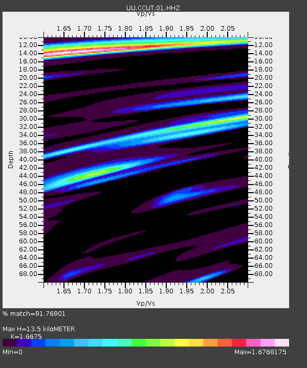
CCUT Cedar City, UT, USA - Earthquake Result Viewer

Earthquake location: Andreanof Islands, Aleutian Is.
Earthquake latitude/longitude: 51.6/-174.7
Earthquake time(UTC): 2013/09/15 (258) 16:21:37 GMT
Earthquake Depth: 24 km
Earthquake Magnitude: 6.1 MWW, 5.7 MI, 5.7 ML, 6.0 MWB, 6.1 MWC, 6.1 MWW
Earthquake Catalog/Contributor: NEIC PDE/NEIC COMCAT
Network: UU University of Utah Regional Network
Station: CCUT Cedar City, UT, USA
Lat/Lon: 37.55 N/113.36 W
Elevation: 2127 m
Distance: 44.6 deg
Az: 83.376 deg
Baz: 308.745 deg
Ray Param: 0.07177791
Estimated Moho Depth: 13.5 km
Estimated Crust Vp/Vs: 1.67
Assumed Crust Vp: 6.194 km/s
Estimated Crust Vs: 3.715 km/s
Estimated Crust Poisson's Ratio: 0.22
Radial Match: 91.76901 %
Radial Bump: 400
Transverse Match: 85.12545 %
Transverse Bump: 400
SOD ConfigId: 626651
Insert Time: 2014-04-18 17:43:05.824 +0000
GWidth: 2.5
Max Bumps: 400
Tol: 0.001

Signal To Noise

ChannelStoNSTALTA
UU:CCUT:01:HHZ:20130915T16:29:16.599005Z2.08327911.74729E-78.38721E-8
UU:CCUT:01:HHN:20130915T16:29:16.599005Z1.96119611.4573862E-77.4311096E-8
UU:CCUT:01:HHE:20130915T16:29:16.599005Z0.95326588.041815E-88.436067E-8
Arrivals
Ps1.6 SECOND
PpPs5.5 SECOND
PsPs/PpSs7.0 SECOND