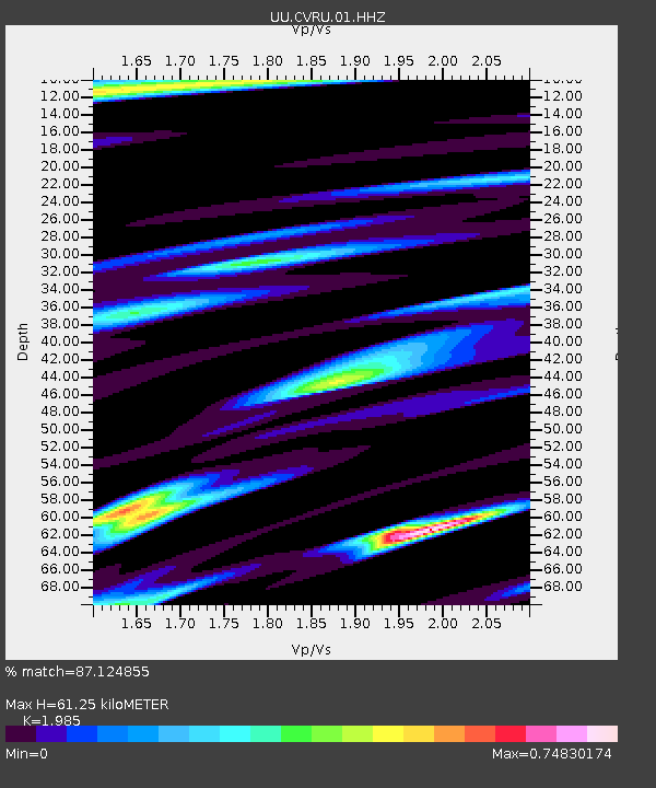
CVRU Castle Valley Ranch, Emery, UT, USA old TA-Q16A - Earthquake Result Viewer
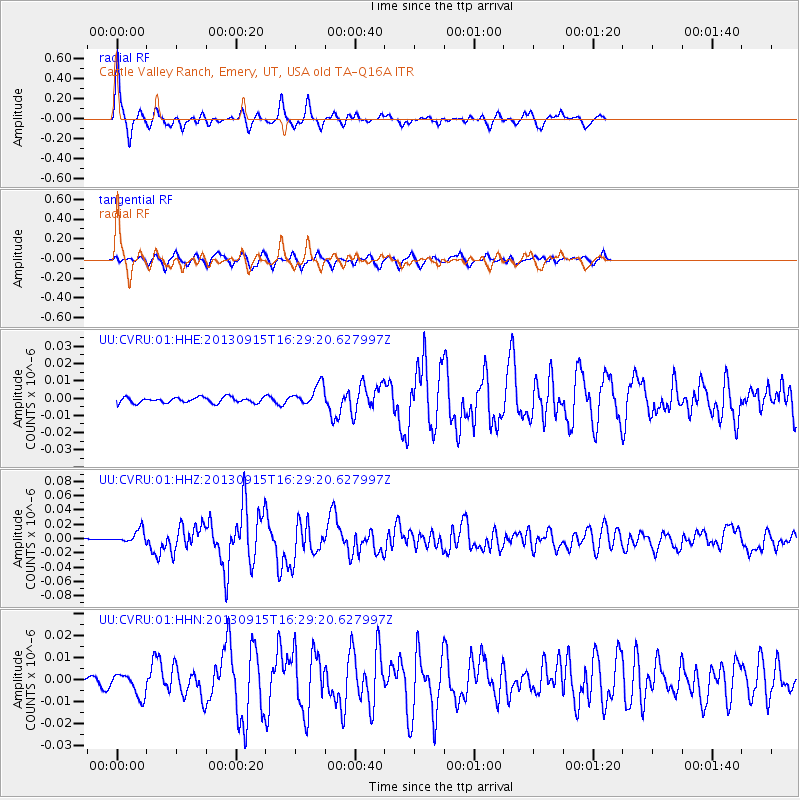
Earthquake location: Andreanof Islands, Aleutian Is.
Earthquake latitude/longitude: 51.6/-174.7
Earthquake time(UTC): 2013/09/15 (258) 16:21:37 GMT
Earthquake Depth: 24 km
Earthquake Magnitude: 6.1 MWW, 5.7 MI, 5.7 ML, 6.0 MWB, 6.1 MWC, 6.1 MWW
Earthquake Catalog/Contributor: NEIC PDE/NEIC COMCAT
Network: UU University of Utah Regional Network
Station: CVRU Castle Valley Ranch, Emery, UT, USA old TA-Q16A
Lat/Lon: 38.92 N/111.17 W
Elevation: 1912 m
Distance: 45.1 deg
Az: 80.341 deg
Baz: 307.944 deg
Ray Param: 0.07145519
Estimated Moho Depth: 61.25 km
Estimated Crust Vp/Vs: 1.99
Assumed Crust Vp: 6.207 km/s
Estimated Crust Vs: 3.127 km/s
Estimated Crust Poisson's Ratio: 0.33
Radial Match: 87.124855 %
Radial Bump: 235
Transverse Match: 79.99258 %
Transverse Bump: 400
SOD ConfigId: 626651
Insert Time: 2014-04-18 17:43:11.512 +0000
GWidth: 2.5
Max Bumps: 400
Tol: 0.001

Signal To Noise

ChannelStoNSTALTA
UU:CVRU:01:HHZ:20130915T16:29:20.627997Z3.03789459.301592E-93.061855E-9
UU:CVRU:01:HHN:20130915T16:29:20.627997Z2.5357755.2943885E-92.0878779E-9
UU:CVRU:01:HHE:20130915T16:29:20.627997Z3.67221986.0349317E-91.6434015E-9
Arrivals
Ps10 SECOND
PpPs28 SECOND
PsPs/PpSs38 SECOND