You are here: Home > Network List > PS - Pacific21 Stations List
> Station PSI Parapat, Indonesia > Earthquake Result Viewer
PSI Parapat, Indonesia - Earthquake Result Viewer

| Earthquake location: |
Eastern Honshu, Japan |
| Earthquake latitude/longitude: |
36.6/137.9 |
| Earthquake time(UTC): |
2014/11/22 (326) 13:08:18 GMT |
| Earthquake Depth: |
10 km |
| Earthquake Magnitude: |
6.2 MWP |
| Earthquake Catalog/Contributor: |
NEIC PDE/NEIC COMCAT |
|
| Network: |
PS Pacific21 |
| Station: |
PSI Parapat, Indonesia |
| Lat/Lon: |
2.69 N/98.92 E |
| Elevation: |
987 m |
|
| Distance: |
49.3 deg |
| Az: |
236.005 deg |
| Baz: |
41.88 deg |
| Ray Param: |
0.0687949 |
| Estimated Moho Depth: |
50.5 km |
| Estimated Crust Vp/Vs: |
1.75 |
| Assumed Crust Vp: |
6.468 km/s |
| Estimated Crust Vs: |
3.685 km/s |
| Estimated Crust Poisson's Ratio: |
0.26 |
|
| Radial Match: |
93.41049 % |
| Radial Bump: |
400 |
| Transverse Match: |
86.78595 % |
| Transverse Bump: |
400 |
| SOD ConfigId: |
3390531 |
| Insert Time: |
2019-04-15 04:07:08.600 +0000 |
| GWidth: |
2.5 |
| Max Bumps: |
400 |
| Tol: |
0.001 |
|
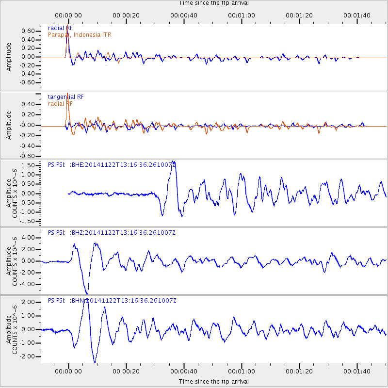
Signal To Noise
| Channel | StoN | STA | LTA |
| PS:PSI: :BHZ:20141122T13:16:36.261007Z | 20.037199 | 1.5573257E-6 | 7.772173E-8 |
| PS:PSI: :BHN:20141122T13:16:36.261007Z | 14.720353 | 7.0199496E-7 | 4.7688733E-8 |
| PS:PSI: :BHE:20141122T13:16:36.261007Z | 12.130103 | 5.7370517E-7 | 4.7295984E-8 |
| Arrivals |
| Ps | 6.3 SECOND |
| PpPs | 20 SECOND |
| PsPs/PpSs | 27 SECOND |


