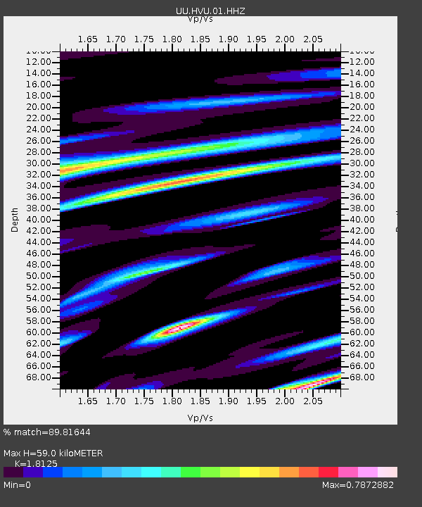
HVU Hansel Valley, UT, USA - Earthquake Result Viewer
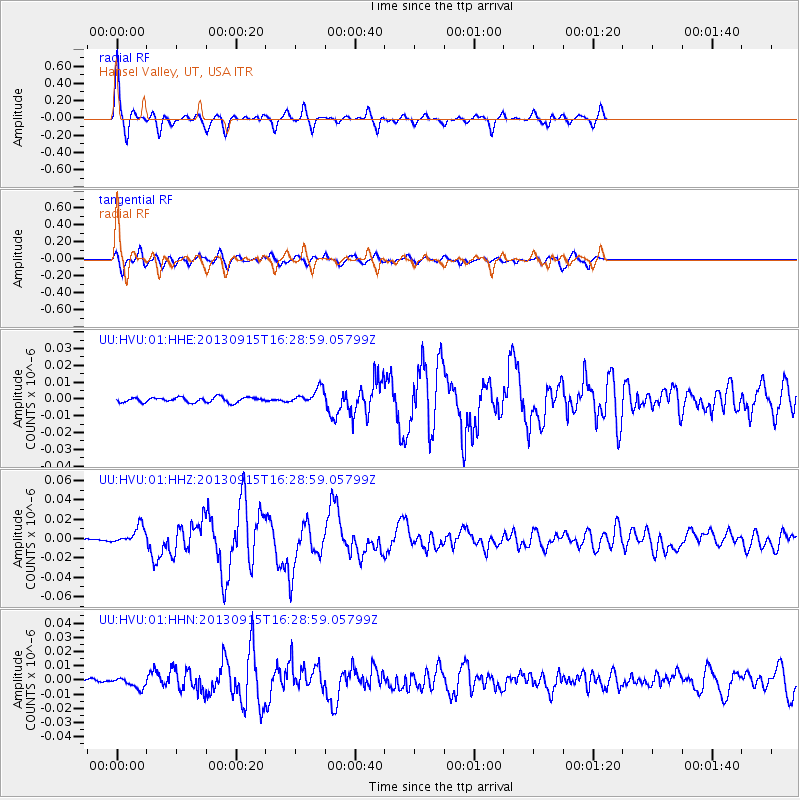
Earthquake location: Andreanof Islands, Aleutian Is.
Earthquake latitude/longitude: 51.6/-174.7
Earthquake time(UTC): 2013/09/15 (258) 16:21:37 GMT
Earthquake Depth: 24 km
Earthquake Magnitude: 6.1 MWW, 5.7 MI, 5.7 ML, 6.0 MWB, 6.1 MWC, 6.1 MWW
Earthquake Catalog/Contributor: NEIC PDE/NEIC COMCAT
Network: UU University of Utah Regional Network
Station: HVU Hansel Valley, UT, USA
Lat/Lon: 41.78 N/112.78 W
Elevation: 1609 m
Distance: 42.4 deg
Az: 78.08 deg
Baz: 305.276 deg
Ray Param: 0.073149115
Estimated Moho Depth: 59.0 km
Estimated Crust Vp/Vs: 1.81
Assumed Crust Vp: 6.276 km/s
Estimated Crust Vs: 3.463 km/s
Estimated Crust Poisson's Ratio: 0.28
Radial Match: 89.81644 %
Radial Bump: 270
Transverse Match: 78.6677 %
Transverse Bump: 400
SOD ConfigId: 626651
Insert Time: 2014-04-18 17:43:15.689 +0000
GWidth: 2.5
Max Bumps: 400
Tol: 0.001

Signal To Noise

ChannelStoNSTALTA
UU:HVU:01:HHZ:20130915T16:28:59.05799Z5.0611839.1582955E-91.8095168E-9
UU:HVU:01:HHN:20130915T16:28:59.05799Z1.66458313.851105E-92.3135556E-9
UU:HVU:01:HHE:20130915T16:28:59.05799Z3.0713594.5180513E-91.4710267E-9
Arrivals
Ps8.1 SECOND
PpPs25 SECOND
PsPs/PpSs33 SECOND