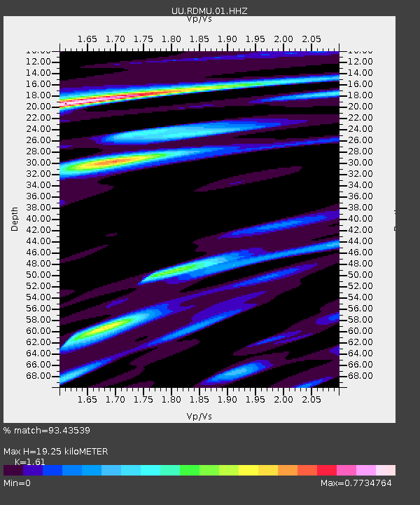
RDMU Red Mountain, UT, USA - Earthquake Result Viewer
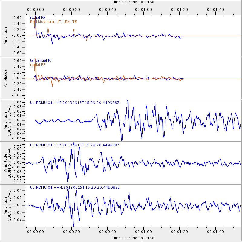
Earthquake location: Andreanof Islands, Aleutian Is.
Earthquake latitude/longitude: 51.6/-174.7
Earthquake time(UTC): 2013/09/15 (258) 16:21:37 GMT
Earthquake Depth: 24 km
Earthquake Magnitude: 6.1 MWW, 5.7 MI, 5.7 ML, 6.0 MWB, 6.1 MWC, 6.1 MWW
Earthquake Catalog/Contributor: NEIC PDE/NEIC COMCAT
Network: UU University of Utah Regional Network
Station: RDMU Red Mountain, UT, USA
Lat/Lon: 40.57 N/109.57 W
Elevation: 2087 m
Distance: 45.1 deg
Az: 77.43 deg
Baz: 306.909 deg
Ray Param: 0.07146999
Estimated Moho Depth: 19.25 km
Estimated Crust Vp/Vs: 1.61
Assumed Crust Vp: 6.207 km/s
Estimated Crust Vs: 3.855 km/s
Estimated Crust Poisson's Ratio: 0.19
Radial Match: 93.43539 %
Radial Bump: 338
Transverse Match: 84.401344 %
Transverse Bump: 400
SOD ConfigId: 626651
Insert Time: 2014-04-18 17:43:39.047 +0000
GWidth: 2.5
Max Bumps: 400
Tol: 0.001

Signal To Noise

ChannelStoNSTALTA
UU:RDMU:01:HHZ:20130915T16:29:20.449988Z9.0833431.6284886E-81.7928297E-9
UU:RDMU:01:HHN:20130915T16:29:20.449988Z3.43132856.623229E-91.9302229E-9
UU:RDMU:01:HHE:20130915T16:29:20.449988Z2.98253376.556593E-92.1983297E-9
Arrivals
Ps2.0 SECOND
PpPs7.6 SECOND
PsPs/PpSs9.6 SECOND