You are here: Home > Network List > UW - Pacific Northwest Regional Seismic Network Stations List
> Station MRBL Marblemount, WA, USA > Earthquake Result Viewer
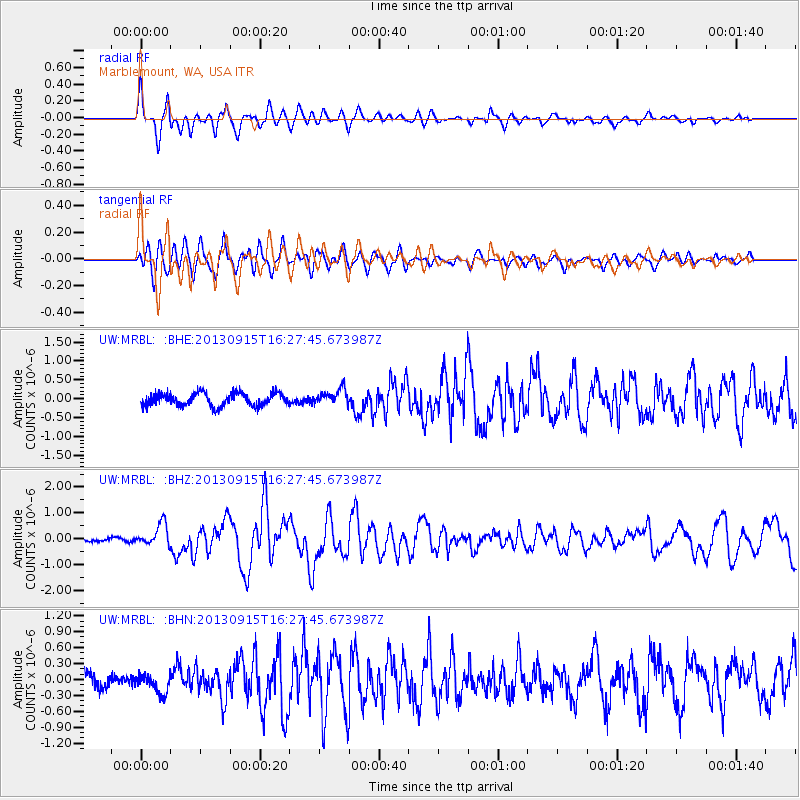
MRBL Marblemount, WA, USA - Earthquake Result Viewer
*The percent match for this event was below the threshold and hence no stack was calculated.
| Earthquake location: |
Andreanof Islands, Aleutian Is. |
| Earthquake latitude/longitude: |
51.6/-174.7 |
| Earthquake time(UTC): |
2013/09/15 (258) 16:21:37 GMT |
| Earthquake Depth: |
24 km |
| Earthquake Magnitude: |
6.1 MWW, 5.7 MI, 5.7 ML, 6.0 MWB, 6.1 MWC, 6.1 MWW |
| Earthquake Catalog/Contributor: |
NEIC PDE/NEIC COMCAT |
|
| Network: |
UW Pacific Northwest Regional Seismic Network |
| Station: |
MRBL Marblemount, WA, USA |
| Lat/Lon: |
48.52 N/121.48 W |
| Elevation: |
75 m |
|
| Distance: |
33.7 deg |
| Az: |
73.758 deg |
| Baz: |
295.692 deg |
| Ray Param: |
$rayparam |
*The percent match for this event was below the threshold and hence was not used in the summary stack. |
|
| Radial Match: |
71.28979 % |
| Radial Bump: |
400 |
| Transverse Match: |
64.58527 % |
| Transverse Bump: |
400 |
| SOD ConfigId: |
626651 |
| Insert Time: |
2014-04-18 17:44:36.198 +0000 |
| GWidth: |
2.5 |
| Max Bumps: |
400 |
| Tol: |
0.001 |
|
Signal To Noise
| Channel | StoN | STA | LTA |
| UW:MRBL: :BHZ:20130915T16:27:45.673987Z | 5.220233 | 4.2529814E-7 | 8.147111E-8 |
| UW:MRBL: :BHN:20130915T16:27:45.673987Z | 1.0337596 | 1.7944372E-7 | 1.7358362E-7 |
| UW:MRBL: :BHE:20130915T16:27:45.673987Z | 1.2051432 | 2.0057402E-7 | 1.664317E-7 |
| Arrivals |
| Ps | |
| PpPs | |
| PsPs/PpSs | |


