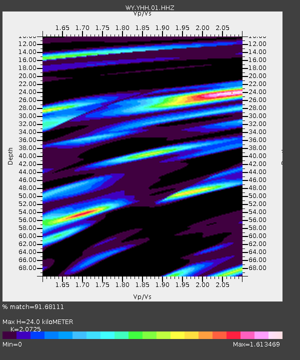
YHH Holmes Hill, YNP, WY, USA - Earthquake Result Viewer
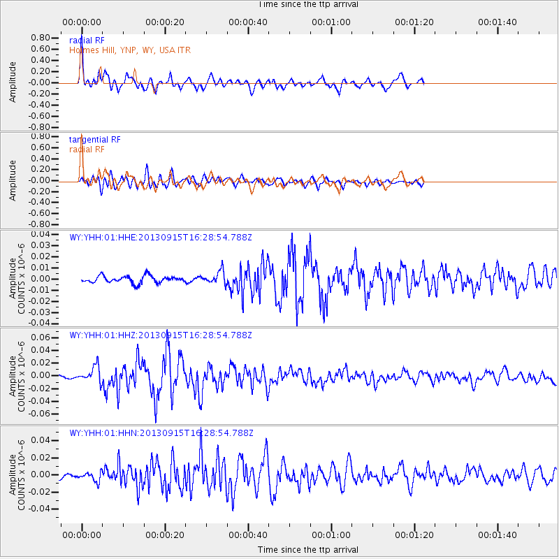
Earthquake location: Andreanof Islands, Aleutian Is.
Earthquake latitude/longitude: 51.6/-174.7
Earthquake time(UTC): 2013/09/15 (258) 16:21:37 GMT
Earthquake Depth: 24 km
Earthquake Magnitude: 6.1 MWW, 5.7 MI, 5.7 ML, 6.0 MWB, 6.1 MWC, 6.1 MWW
Earthquake Catalog/Contributor: NEIC PDE/NEIC COMCAT
Network: WY Yellowstone Wyoming Seismic Network
Station: YHH Holmes Hill, YNP, WY, USA
Lat/Lon: 44.79 N/110.85 W
Elevation: 2717 m
Distance: 41.9 deg
Az: 73.196 deg
Baz: 302.97 deg
Ray Param: 0.07346058
Estimated Moho Depth: 24.0 km
Estimated Crust Vp/Vs: 2.07
Assumed Crust Vp: 6.35 km/s
Estimated Crust Vs: 3.064 km/s
Estimated Crust Poisson's Ratio: 0.35
Radial Match: 91.68111 %
Radial Bump: 387
Transverse Match: 77.50644 %
Transverse Bump: 400
SOD ConfigId: 626651
Insert Time: 2014-04-18 17:46:22.136 +0000
GWidth: 2.5
Max Bumps: 400
Tol: 0.001

Signal To Noise

ChannelStoNSTALTA
WY:YHH:01:HHZ:20130915T16:28:54.788Z5.43963241.289211E-82.370033E-9
WY:YHH:01:HHN:20130915T16:28:54.788Z2.24007875.3422737E-92.3848599E-9
WY:YHH:01:HHE:20130915T16:28:54.788Z1.88821715.9388228E-93.1452012E-9
Arrivals
Ps4.3 SECOND
PpPs11 SECOND
PsPs/PpSs15 SECOND