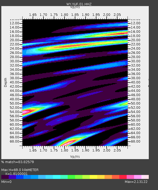
YUF Upper Falls, WY, USA - Earthquake Result Viewer
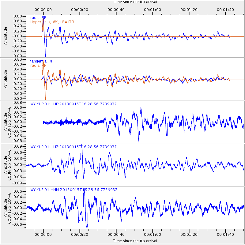
Earthquake location: Andreanof Islands, Aleutian Is.
Earthquake latitude/longitude: 51.6/-174.7
Earthquake time(UTC): 2013/09/15 (258) 16:21:37 GMT
Earthquake Depth: 24 km
Earthquake Magnitude: 6.1 MWW, 5.7 MI, 5.7 ML, 6.0 MWB, 6.1 MWC, 6.1 MWW
Earthquake Catalog/Contributor: NEIC PDE/NEIC COMCAT
Network: WY Yellowstone Wyoming Seismic Network
Station: YUF Upper Falls, WY, USA
Lat/Lon: 44.71 N/110.51 W
Elevation: 2394 m
Distance: 42.1 deg
Az: 73.094 deg
Baz: 303.132 deg
Ray Param: 0.073310025
Estimated Moho Depth: 69.0 km
Estimated Crust Vp/Vs: 1.81
Assumed Crust Vp: 6.35 km/s
Estimated Crust Vs: 3.508 km/s
Estimated Crust Poisson's Ratio: 0.28
Radial Match: 83.82579 %
Radial Bump: 400
Transverse Match: 76.80116 %
Transverse Bump: 400
SOD ConfigId: 626651
Insert Time: 2014-04-18 17:46:47.582 +0000
GWidth: 2.5
Max Bumps: 400
Tol: 0.001

Signal To Noise

ChannelStoNSTALTA
WY:YUF:01:HHZ:20130915T16:28:56.773993Z5.0972471.3623402E-82.672698E-9
WY:YUF:01:HHN:20130915T16:28:56.773993Z0.79714994.6550652E-95.839636E-9
WY:YUF:01:HHE:20130915T16:28:56.773993Z1.57004588.073146E-95.1419806E-9
Arrivals
Ps9.4 SECOND
PpPs29 SECOND
PsPs/PpSs38 SECOND