You are here: Home > Network List > YB13 - Continental Dynamics/Cent. Anatolian Tectonics:Surface to Mantle Dynamics During Stations List
> Station AT01 Kalin,Sivas,Turkey > Earthquake Result Viewer
AT01 Kalin,Sivas,Turkey - Earthquake Result Viewer
| Earthquake location: |
Eastern Honshu, Japan |
| Earthquake latitude/longitude: |
36.6/137.9 |
| Earthquake time(UTC): |
2014/11/22 (326) 13:08:18 GMT |
| Earthquake Depth: |
10 km |
| Earthquake Magnitude: |
6.2 MWP |
| Earthquake Catalog/Contributor: |
NEIC PDE/NEIC COMCAT |
|
| Network: |
YB Continental Dynamics/Cent. Anatolian Tectonics:Surface to Mantle Dynamics During |
| Station: |
AT01 Kalin,Sivas,Turkey |
| Lat/Lon: |
39.72 N/36.71 E |
| Elevation: |
1354 m |
|
| Distance: |
75.1 deg |
| Az: |
308.463 deg |
| Baz: |
54.745 deg |
| Ray Param: |
0.051916096 |
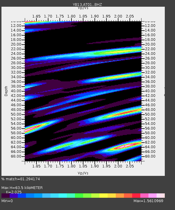
| Estimated Moho Depth: |
63.5 km |
| Estimated Crust Vp/Vs: |
2.03 |
| Assumed Crust Vp: |
6.35 km/s |
| Estimated Crust Vs: |
3.136 km/s |
| Estimated Crust Poisson's Ratio: |
0.34 |
|
| Radial Match: |
81.294174 % |
| Radial Bump: |
400 |
| Transverse Match: |
72.09595 % |
| Transverse Bump: |
400 |
| SOD ConfigId: |
3390531 |
| Insert Time: |
2019-04-15 04:10:21.333 +0000 |
| GWidth: |
2.5 |
| Max Bumps: |
400 |
| Tol: |
0.001 |
|

Signal To Noise
| Channel | StoN | STA | LTA |
| YB:AT01: :BHZ:20141122T13:19:28.819998Z | 5.092754 | 1.3517572E-6 | 2.6542756E-7 |
| YB:AT01: :BHN:20141122T13:19:28.819998Z | 2.9512458 | 9.3459823E-7 | 3.1667923E-7 |
| YB:AT01: :BHE:20141122T13:19:28.819998Z | 1.9715395 | 6.921321E-7 | 3.5106174E-7 |
| Arrivals |
| Ps | 11 SECOND |
| PpPs | 29 SECOND |
| PsPs/PpSs | 40 SECOND |


