You are here: Home > Network List > YB13 - Continental Dynamics/Cent. Anatolian Tectonics:Surface to Mantle Dynamics During Stations List
> Station AT12 Hamzali,Yozgat,Turkey > Earthquake Result Viewer
AT12 Hamzali,Yozgat,Turkey - Earthquake Result Viewer
| Earthquake location: |
Eastern Honshu, Japan |
| Earthquake latitude/longitude: |
36.6/137.9 |
| Earthquake time(UTC): |
2014/11/22 (326) 13:08:18 GMT |
| Earthquake Depth: |
10 km |
| Earthquake Magnitude: |
6.2 MWP |
| Earthquake Catalog/Contributor: |
NEIC PDE/NEIC COMCAT |
|
| Network: |
YB Continental Dynamics/Cent. Anatolian Tectonics:Surface to Mantle Dynamics During |
| Station: |
AT12 Hamzali,Yozgat,Turkey |
| Lat/Lon: |
39.45 N/34.75 E |
| Elevation: |
1007 m |
|
| Distance: |
76.5 deg |
| Az: |
309.153 deg |
| Baz: |
53.666 deg |
| Ray Param: |
0.050983552 |
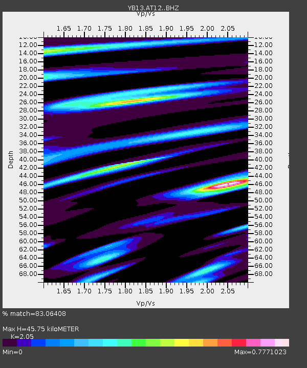
| Estimated Moho Depth: |
45.75 km |
| Estimated Crust Vp/Vs: |
2.05 |
| Assumed Crust Vp: |
6.35 km/s |
| Estimated Crust Vs: |
3.098 km/s |
| Estimated Crust Poisson's Ratio: |
0.34 |
|
| Radial Match: |
83.06408 % |
| Radial Bump: |
400 |
| Transverse Match: |
70.65585 % |
| Transverse Bump: |
400 |
| SOD ConfigId: |
3390531 |
| Insert Time: |
2019-04-15 04:10:25.633 +0000 |
| GWidth: |
2.5 |
| Max Bumps: |
400 |
| Tol: |
0.001 |
|

Signal To Noise
| Channel | StoN | STA | LTA |
| YB:AT12: :BHZ:20141122T13:19:36.73998Z | 7.3273892 | 1.3585167E-6 | 1.8540256E-7 |
| YB:AT12: :BHN:20141122T13:19:36.73998Z | 3.7039917 | 4.5669302E-7 | 1.2329754E-7 |
| YB:AT12: :BHE:20141122T13:19:36.73998Z | 2.3983958 | 3.3240494E-7 | 1.3859469E-7 |
| Arrivals |
| Ps | 7.8 SECOND |
| PpPs | 21 SECOND |
| PsPs/PpSs | 29 SECOND |


