You are here: Home > Network List > TA - USArray Transportable Network (new EarthScope stations) Stations List
> Station 154A Montrose, GA, USA > Earthquake Result Viewer
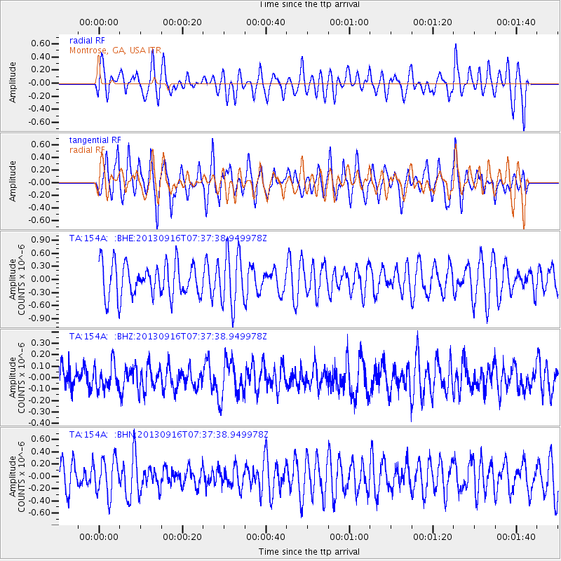
154A Montrose, GA, USA - Earthquake Result Viewer
*The percent match for this event was below the threshold and hence no stack was calculated.
| Earthquake location: |
Southern East Pacific Rise |
| Earthquake latitude/longitude: |
-55.8/-124.2 |
| Earthquake time(UTC): |
2013/09/16 (259) 07:24:48 GMT |
| Earthquake Depth: |
10 km |
| Earthquake Magnitude: |
5.5 MWC, 5.5 MWC |
| Earthquake Catalog/Contributor: |
NEIC PDE/NEIC COMCAT |
|
| Network: |
TA USArray Transportable Network (new EarthScope stations) |
| Station: |
154A Montrose, GA, USA |
| Lat/Lon: |
32.61 N/83.11 W |
| Elevation: |
111 m |
|
| Distance: |
94.8 deg |
| Az: |
33.792 deg |
| Baz: |
201.839 deg |
| Ray Param: |
$rayparam |
*The percent match for this event was below the threshold and hence was not used in the summary stack. |
|
| Radial Match: |
44.237194 % |
| Radial Bump: |
400 |
| Transverse Match: |
54.855877 % |
| Transverse Bump: |
363 |
| SOD ConfigId: |
626651 |
| Insert Time: |
2014-04-18 18:14:33.458 +0000 |
| GWidth: |
2.5 |
| Max Bumps: |
400 |
| Tol: |
0.001 |
|
Signal To Noise
| Channel | StoN | STA | LTA |
| TA:154A: :BHZ:20130916T07:37:38.949978Z | 1.0007342 | 1.099366E-7 | 1.0985594E-7 |
| TA:154A: :BHN:20130916T07:37:38.949978Z | 1.2267773 | 2.989959E-7 | 2.4372466E-7 |
| TA:154A: :BHE:20130916T07:37:38.949978Z | 1.624546 | 6.1354496E-7 | 3.7767165E-7 |
| Arrivals |
| Ps | |
| PpPs | |
| PsPs/PpSs | |


