You are here: Home > Network List > YB13 - Continental Dynamics/Cent. Anatolian Tectonics:Surface to Mantle Dynamics During Stations List
> Station AT23 Ayvazhaci,Kayseri,Turkey > Earthquake Result Viewer
AT23 Ayvazhaci,Kayseri,Turkey - Earthquake Result Viewer
| Earthquake location: |
Eastern Honshu, Japan |
| Earthquake latitude/longitude: |
36.6/137.9 |
| Earthquake time(UTC): |
2014/11/22 (326) 13:08:18 GMT |
| Earthquake Depth: |
10 km |
| Earthquake Magnitude: |
6.2 MWP |
| Earthquake Catalog/Contributor: |
NEIC PDE/NEIC COMCAT |
|
| Network: |
YB Continental Dynamics/Cent. Anatolian Tectonics:Surface to Mantle Dynamics During |
| Station: |
AT23 Ayvazhaci,Kayseri,Turkey |
| Lat/Lon: |
38.36 N/35.55 E |
| Elevation: |
1530 m |
|
| Distance: |
76.6 deg |
| Az: |
307.869 deg |
| Baz: |
53.87 deg |
| Ray Param: |
0.05089184 |
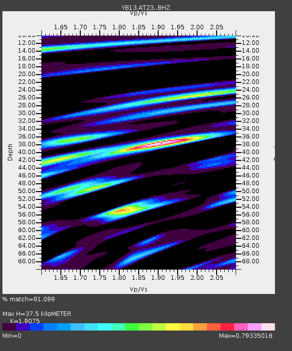
| Estimated Moho Depth: |
37.5 km |
| Estimated Crust Vp/Vs: |
1.91 |
| Assumed Crust Vp: |
6.35 km/s |
| Estimated Crust Vs: |
3.329 km/s |
| Estimated Crust Poisson's Ratio: |
0.31 |
|
| Radial Match: |
91.099 % |
| Radial Bump: |
400 |
| Transverse Match: |
84.705124 % |
| Transverse Bump: |
400 |
| SOD ConfigId: |
3390531 |
| Insert Time: |
2019-04-15 04:10:34.794 +0000 |
| GWidth: |
2.5 |
| Max Bumps: |
400 |
| Tol: |
0.001 |
|

Signal To Noise
| Channel | StoN | STA | LTA |
| YB:AT23: :BHZ:20141122T13:19:37.52001Z | 10.039135 | 1.6929438E-6 | 1.6863444E-7 |
| YB:AT23: :BHN:20141122T13:19:37.52001Z | 2.5952127 | 4.0726474E-7 | 1.5692923E-7 |
| YB:AT23: :BHE:20141122T13:19:37.52001Z | 3.2702003 | 4.747921E-7 | 1.4518747E-7 |
| Arrivals |
| Ps | 5.5 SECOND |
| PpPs | 17 SECOND |
| PsPs/PpSs | 22 SECOND |


