You are here: Home > Network List > TA - USArray Transportable Network (new EarthScope stations) Stations List
> Station WHTX Lake Whitney, Meridian, TX, USA > Earthquake Result Viewer
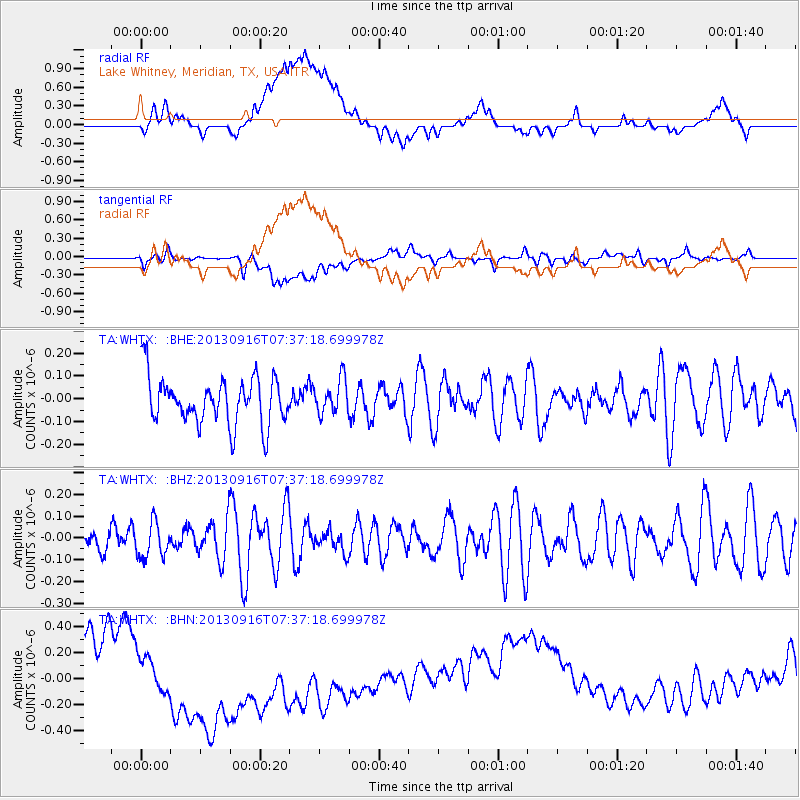
WHTX Lake Whitney, Meridian, TX, USA - Earthquake Result Viewer
*The percent match for this event was below the threshold and hence no stack was calculated.
| Earthquake location: |
Southern East Pacific Rise |
| Earthquake latitude/longitude: |
-55.8/-124.2 |
| Earthquake time(UTC): |
2013/09/16 (259) 07:24:48 GMT |
| Earthquake Depth: |
10 km |
| Earthquake Magnitude: |
5.5 MWC, 5.5 MWC |
| Earthquake Catalog/Contributor: |
NEIC PDE/NEIC COMCAT |
|
| Network: |
TA USArray Transportable Network (new EarthScope stations) |
| Station: |
WHTX Lake Whitney, Meridian, TX, USA |
| Lat/Lon: |
31.99 N/97.46 W |
| Elevation: |
190 m |
|
| Distance: |
90.4 deg |
| Az: |
22.445 deg |
| Baz: |
194.693 deg |
| Ray Param: |
$rayparam |
*The percent match for this event was below the threshold and hence was not used in the summary stack. |
|
| Radial Match: |
19.480303 % |
| Radial Bump: |
400 |
| Transverse Match: |
35.430367 % |
| Transverse Bump: |
400 |
| SOD ConfigId: |
626651 |
| Insert Time: |
2014-04-18 18:16:26.707 +0000 |
| GWidth: |
2.5 |
| Max Bumps: |
400 |
| Tol: |
0.001 |
|
Signal To Noise
| Channel | StoN | STA | LTA |
| TA:WHTX: :BHZ:20130916T07:37:18.699978Z | 0.7947695 | 8.0132516E-8 | 1.0082484E-7 |
| TA:WHTX: :BHN:20130916T07:37:18.699978Z | 1.5893211 | 3.0038575E-7 | 1.8900255E-7 |
| TA:WHTX: :BHE:20130916T07:37:18.699978Z | 0.73290455 | 7.5096956E-8 | 1.0246485E-7 |
| Arrivals |
| Ps | |
| PpPs | |
| PsPs/PpSs | |


