You are here: Home > Network List > AV - Alaska Volcano Observatory Stations List
> Station SPCR Ckakachatna River, Mount Spurr, Alaska > Earthquake Result Viewer
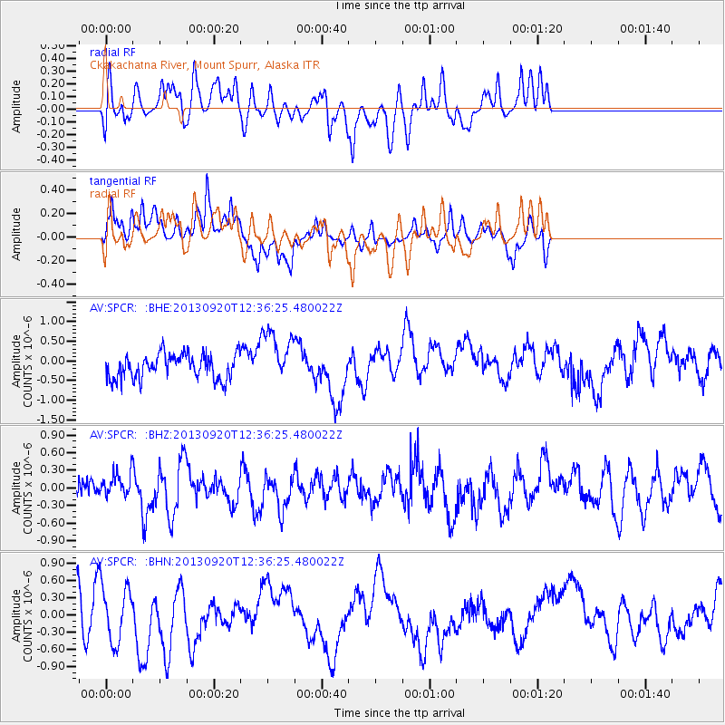
SPCR Ckakachatna River, Mount Spurr, Alaska - Earthquake Result Viewer
*The percent match for this event was below the threshold and hence no stack was calculated.
| Earthquake location: |
Myanmar |
| Earthquake latitude/longitude: |
22.9/96.0 |
| Earthquake time(UTC): |
2013/09/20 (263) 12:24:46 GMT |
| Earthquake Depth: |
4.0 km |
| Earthquake Magnitude: |
5.7 MWW, 5.6 MWB, 5.7 MWC, 5.7 MWW |
| Earthquake Catalog/Contributor: |
NEIC PDE/NEIC COMCAT |
|
| Network: |
AV Alaska Volcano Observatory |
| Station: |
SPCR Ckakachatna River, Mount Spurr, Alaska |
| Lat/Lon: |
61.20 N/152.21 W |
| Elevation: |
984 m |
|
| Distance: |
80.0 deg |
| Az: |
27.155 deg |
| Baz: |
299.671 deg |
| Ray Param: |
$rayparam |
*The percent match for this event was below the threshold and hence was not used in the summary stack. |
|
| Radial Match: |
51.230026 % |
| Radial Bump: |
400 |
| Transverse Match: |
47.11043 % |
| Transverse Bump: |
337 |
| SOD ConfigId: |
626651 |
| Insert Time: |
2014-04-18 18:22:54.934 +0000 |
| GWidth: |
2.5 |
| Max Bumps: |
400 |
| Tol: |
0.001 |
|
Signal To Noise
| Channel | StoN | STA | LTA |
| AV:SPCR: :BHZ:20130920T12:36:25.480022Z | 0.74820197 | 1.9895715E-7 | 2.659137E-7 |
| AV:SPCR: :BHN:20130920T12:36:25.480022Z | 1.4304949 | 4.7050926E-7 | 3.2891361E-7 |
| AV:SPCR: :BHE:20130920T12:36:25.480022Z | 2.1575189 | 6.775973E-7 | 3.1406324E-7 |
| Arrivals |
| Ps | |
| PpPs | |
| PsPs/PpSs | |


