You are here: Home > Network List > IU - Global Seismograph Network (GSN - IRIS/USGS) Stations List
> Station CTAO Charters Towers, Australia > Earthquake Result Viewer
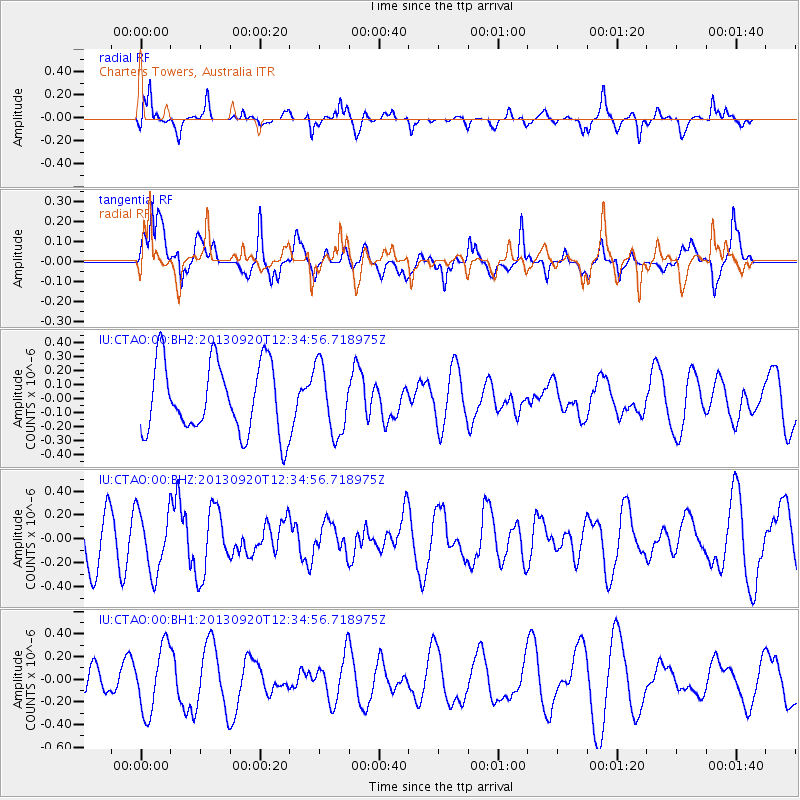
CTAO Charters Towers, Australia - Earthquake Result Viewer
*The percent match for this event was below the threshold and hence no stack was calculated.
| Earthquake location: |
Myanmar |
| Earthquake latitude/longitude: |
22.9/96.0 |
| Earthquake time(UTC): |
2013/09/20 (263) 12:24:46 GMT |
| Earthquake Depth: |
4.0 km |
| Earthquake Magnitude: |
5.7 MWW, 5.6 MWB, 5.7 MWC, 5.7 MWW |
| Earthquake Catalog/Contributor: |
NEIC PDE/NEIC COMCAT |
|
| Network: |
IU Global Seismograph Network (GSN - IRIS/USGS) |
| Station: |
CTAO Charters Towers, Australia |
| Lat/Lon: |
20.09 S/146.25 E |
| Elevation: |
357 m |
|
| Distance: |
65.1 deg |
| Az: |
127.127 deg |
| Baz: |
308.555 deg |
| Ray Param: |
$rayparam |
*The percent match for this event was below the threshold and hence was not used in the summary stack. |
|
| Radial Match: |
70.5439 % |
| Radial Bump: |
339 |
| Transverse Match: |
66.47386 % |
| Transverse Bump: |
400 |
| SOD ConfigId: |
626651 |
| Insert Time: |
2014-04-18 18:26:11.433 +0000 |
| GWidth: |
2.5 |
| Max Bumps: |
400 |
| Tol: |
0.001 |
|
Signal To Noise
| Channel | StoN | STA | LTA |
| IU:CTAO:00:BHZ:20130920T12:34:56.718975Z | 0.9899278 | 2.5552143E-7 | 2.5812125E-7 |
| IU:CTAO:00:BH1:20130920T12:34:56.718975Z | 2.1656978 | 2.898598E-7 | 1.3384128E-7 |
| IU:CTAO:00:BH2:20130920T12:34:56.718975Z | 0.9712306 | 2.4179565E-7 | 2.4895803E-7 |
| Arrivals |
| Ps | |
| PpPs | |
| PsPs/PpSs | |


