You are here: Home > Network List > G - GEOSCOPE Stations List
> Station NOUC Port Laguerre, New Caledonia > Earthquake Result Viewer
NOUC Port Laguerre, New Caledonia - Earthquake Result Viewer
| Earthquake location: |
Flores Sea |
| Earthquake latitude/longitude: |
-7.3/120.0 |
| Earthquake time(UTC): |
2013/09/21 (264) 01:39:15 GMT |
| Earthquake Depth: |
550 km |
| Earthquake Magnitude: |
6.1 MWW, 6.0 MWC, 6.1 MWW, 6.1 MWC, 6.1 MWB |
| Earthquake Catalog/Contributor: |
NEIC PDE/NEIC COMCAT |
|
| Network: |
G GEOSCOPE |
| Station: |
NOUC Port Laguerre, New Caledonia |
| Lat/Lon: |
22.10 S/166.30 E |
| Elevation: |
112 m |
|
| Distance: |
46.9 deg |
| Az: |
113.38 deg |
| Baz: |
280.958 deg |
| Ray Param: |
0.06772474 |
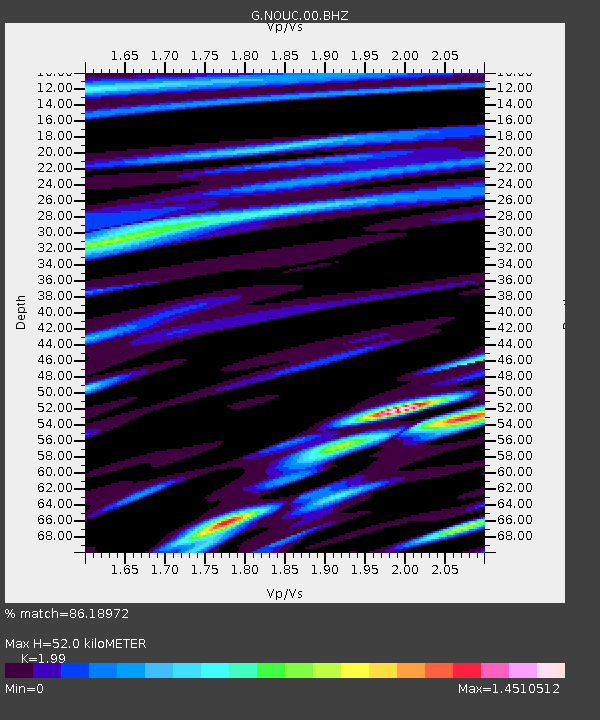
| Estimated Moho Depth: |
52.0 km |
| Estimated Crust Vp/Vs: |
1.99 |
| Assumed Crust Vp: |
5.14 km/s |
| Estimated Crust Vs: |
2.583 km/s |
| Estimated Crust Poisson's Ratio: |
0.33 |
|
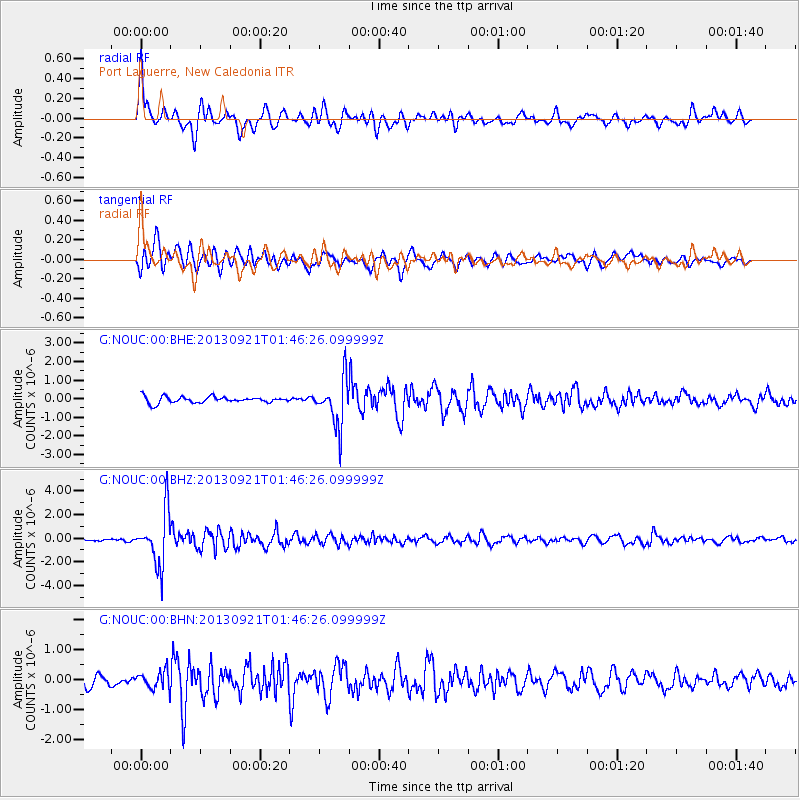
| Radial Match: |
86.18972 % |
| Radial Bump: |
400 |
| Transverse Match: |
80.858765 % |
| Transverse Bump: |
400 |
| SOD ConfigId: |
626651 |
| Insert Time: |
2014-04-18 18:30:58.933 +0000 |
| GWidth: |
2.5 |
| Max Bumps: |
400 |
| Tol: |
0.001 |
|
Signal To Noise
| Channel | StoN | STA | LTA |
| G:NOUC:00:BHZ:20130921T01:46:26.099999Z | 13.437444 | 2.2360318E-6 | 1.6640307E-7 |
| G:NOUC:00:BHN:20130921T01:46:26.099999Z | 1.7079128 | 2.8991784E-7 | 1.697498E-7 |
| G:NOUC:00:BHE:20130921T01:46:26.099999Z | 7.3752956 | 1.2534724E-6 | 1.6995554E-7 |
| Arrivals |
| Ps | 10 SECOND |
| PpPs | 29 SECOND |
| PsPs/PpSs | 40 SECOND |


