You are here: Home > Network List > G - GEOSCOPE Stations List
> Station SANVU Espiritu Santo, Vanuatu > Earthquake Result Viewer
SANVU Espiritu Santo, Vanuatu - Earthquake Result Viewer
| Earthquake location: |
Flores Sea |
| Earthquake latitude/longitude: |
-7.3/120.0 |
| Earthquake time(UTC): |
2013/09/21 (264) 01:39:15 GMT |
| Earthquake Depth: |
550 km |
| Earthquake Magnitude: |
6.1 MWW, 6.0 MWC, 6.1 MWW, 6.1 MWC, 6.1 MWB |
| Earthquake Catalog/Contributor: |
NEIC PDE/NEIC COMCAT |
|
| Network: |
G GEOSCOPE |
| Station: |
SANVU Espiritu Santo, Vanuatu |
| Lat/Lon: |
15.45 S/167.20 E |
| Elevation: |
56 m |
|
| Distance: |
46.9 deg |
| Az: |
104.236 deg |
| Baz: |
274.414 deg |
| Ray Param: |
0.06774798 |
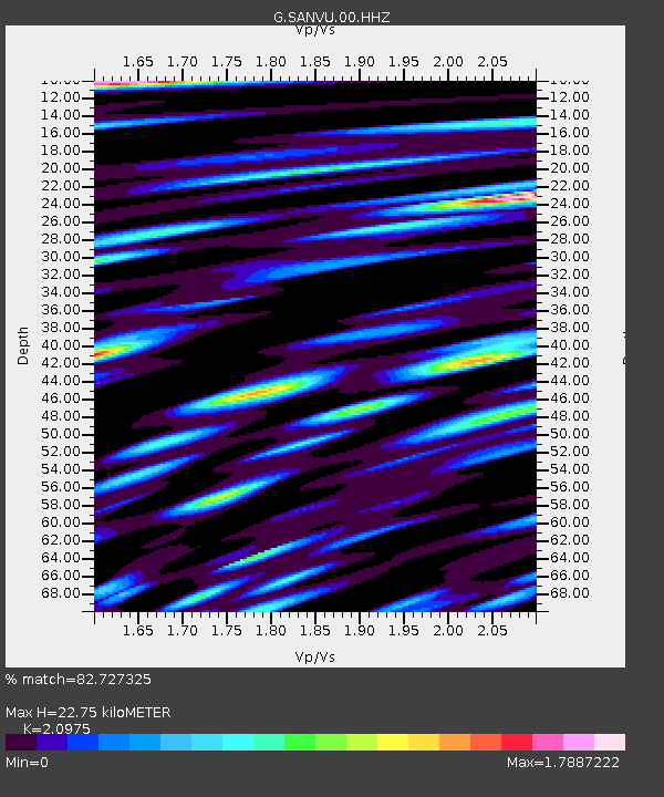
| Estimated Moho Depth: |
22.75 km |
| Estimated Crust Vp/Vs: |
2.10 |
| Assumed Crust Vp: |
4.802 km/s |
| Estimated Crust Vs: |
2.289 km/s |
| Estimated Crust Poisson's Ratio: |
0.35 |
|
| Radial Match: |
82.727325 % |
| Radial Bump: |
400 |
| Transverse Match: |
71.62686 % |
| Transverse Bump: |
400 |
| SOD ConfigId: |
626651 |
| Insert Time: |
2014-04-18 18:31:05.317 +0000 |
| GWidth: |
2.5 |
| Max Bumps: |
400 |
| Tol: |
0.001 |
|

Signal To Noise
| Channel | StoN | STA | LTA |
| G:SANVU:00:HHZ:20130921T01:46:25.779991Z | 24.410654 | 5.829314E-6 | 2.3880204E-7 |
| G:SANVU:00:HHN:20130921T01:46:25.779991Z | 2.2630975 | 6.010125E-7 | 2.6557075E-7 |
| G:SANVU:00:HHE:20130921T01:46:25.779991Z | 8.551334 | 2.1216833E-6 | 2.4811138E-7 |
| Arrivals |
| Ps | 5.3 SECOND |
| PpPs | 14 SECOND |
| PsPs/PpSs | 20 SECOND |


