You are here: Home > Network List > IC - New China Digital Seismograph Network Stations List
> Station KMI Kunming, Yunnan Province, China > Earthquake Result Viewer
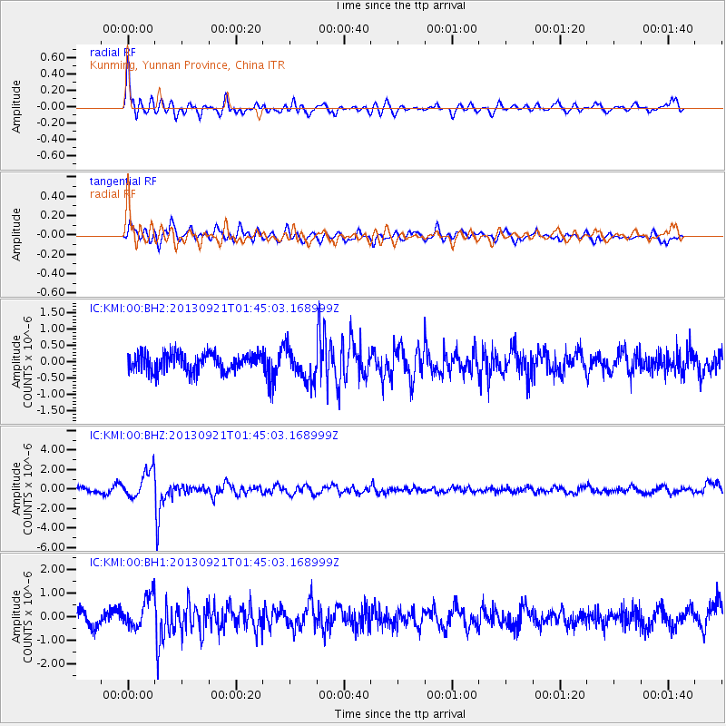
KMI Kunming, Yunnan Province, China - Earthquake Result Viewer
*The percent match for this event was below the threshold and hence no stack was calculated.
| Earthquake location: |
Flores Sea |
| Earthquake latitude/longitude: |
-7.3/120.0 |
| Earthquake time(UTC): |
2013/09/21 (264) 01:39:15 GMT |
| Earthquake Depth: |
550 km |
| Earthquake Magnitude: |
6.1 MWW, 6.0 MWC, 6.1 MWW, 6.1 MWC, 6.1 MWB |
| Earthquake Catalog/Contributor: |
NEIC PDE/NEIC COMCAT |
|
| Network: |
IC New China Digital Seismograph Network |
| Station: |
KMI Kunming, Yunnan Province, China |
| Lat/Lon: |
25.12 N/102.74 E |
| Elevation: |
1975 m |
|
| Distance: |
36.4 deg |
| Az: |
333.016 deg |
| Baz: |
150.231 deg |
| Ray Param: |
$rayparam |
*The percent match for this event was below the threshold and hence was not used in the summary stack. |
|
| Radial Match: |
77.617226 % |
| Radial Bump: |
400 |
| Transverse Match: |
76.302864 % |
| Transverse Bump: |
400 |
| SOD ConfigId: |
626651 |
| Insert Time: |
2014-04-18 18:32:03.975 +0000 |
| GWidth: |
2.5 |
| Max Bumps: |
400 |
| Tol: |
0.001 |
|
Signal To Noise
| Channel | StoN | STA | LTA |
| IC:KMI:00:BHZ:20130921T01:45:03.168999Z | 7.3335137 | 1.4674509E-6 | 2.0010202E-7 |
| IC:KMI:00:BH1:20130921T01:45:03.168999Z | 2.6043801 | 7.06928E-7 | 2.7143813E-7 |
| IC:KMI:00:BH2:20130921T01:45:03.168999Z | 1.8253226 | 4.951733E-7 | 2.7127987E-7 |
| Arrivals |
| Ps | |
| PpPs | |
| PsPs/PpSs | |


