You are here: Home > Network List > AZ - ANZA Regional Network Stations List
> Station FRD AZ.FRD > Earthquake Result Viewer
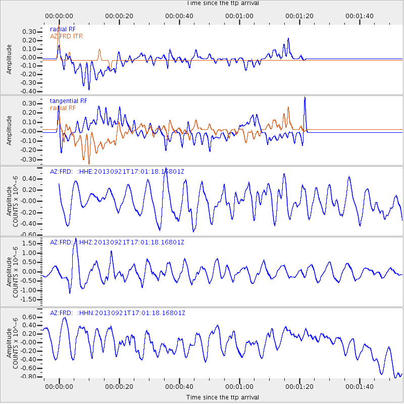
FRD AZ.FRD - Earthquake Result Viewer
*The percent match for this event was below the threshold and hence no stack was calculated.
| Earthquake location: |
South Of Kermadec Islands |
| Earthquake latitude/longitude: |
-33.5/-178.0 |
| Earthquake time(UTC): |
2013/09/21 (264) 16:48:58 GMT |
| Earthquake Depth: |
10 km |
| Earthquake Magnitude: |
5.8 MWW, 5.7 MWC, 5.8 MWW |
| Earthquake Catalog/Contributor: |
NEIC PDE/NEIC COMCAT |
|
| Network: |
AZ ANZA Regional Network |
| Station: |
FRD AZ.FRD |
| Lat/Lon: |
33.49 N/116.60 W |
| Elevation: |
1164 m |
|
| Distance: |
88.2 deg |
| Az: |
47.239 deg |
| Baz: |
227.228 deg |
| Ray Param: |
$rayparam |
*The percent match for this event was below the threshold and hence was not used in the summary stack. |
|
| Radial Match: |
29.299082 % |
| Radial Bump: |
400 |
| Transverse Match: |
24.387571 % |
| Transverse Bump: |
400 |
| SOD ConfigId: |
626651 |
| Insert Time: |
2014-04-18 18:38:25.671 +0000 |
| GWidth: |
2.5 |
| Max Bumps: |
400 |
| Tol: |
0.001 |
|
Signal To Noise
| Channel | StoN | STA | LTA |
| AZ:FRD: :HHZ:20130921T17:01:18.16801Z | 2.33999 | 5.2134715E-7 | 2.2279889E-7 |
| AZ:FRD: :HHN:20130921T17:01:18.16801Z | 1.7495106 | 5.969634E-7 | 3.4121737E-7 |
| AZ:FRD: :HHE:20130921T17:01:18.16801Z | 1.7741731 | 3.172454E-7 | 1.788131E-7 |
| Arrivals |
| Ps | |
| PpPs | |
| PsPs/PpSs | |


