You are here: Home > Network List > II - Global Seismograph Network (GSN - IRIS/IDA) Stations List
> Station WRAB Tennant Creek, NT, Australia > Earthquake Result Viewer
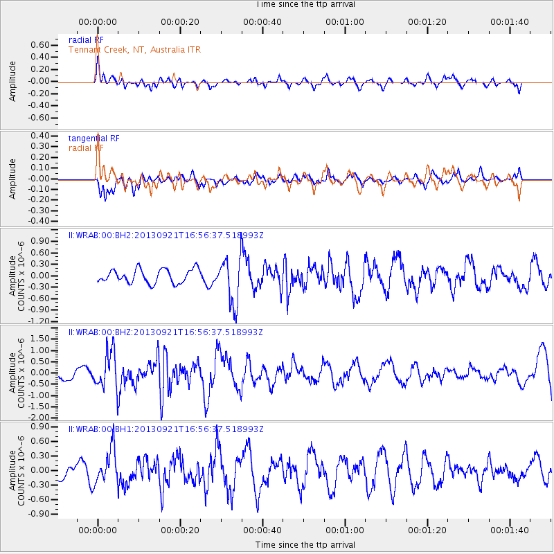
WRAB Tennant Creek, NT, Australia - Earthquake Result Viewer
*The percent match for this event was below the threshold and hence no stack was calculated.
| Earthquake location: |
South Of Kermadec Islands |
| Earthquake latitude/longitude: |
-33.5/-178.0 |
| Earthquake time(UTC): |
2013/09/21 (264) 16:48:58 GMT |
| Earthquake Depth: |
10 km |
| Earthquake Magnitude: |
5.8 MWW, 5.7 MWC, 5.8 MWW |
| Earthquake Catalog/Contributor: |
NEIC PDE/NEIC COMCAT |
|
| Network: |
II Global Seismograph Network (GSN - IRIS/IDA) |
| Station: |
WRAB Tennant Creek, NT, Australia |
| Lat/Lon: |
19.93 S/134.36 E |
| Elevation: |
366 m |
|
| Distance: |
44.3 deg |
| Az: |
275.371 deg |
| Baz: |
117.853 deg |
| Ray Param: |
$rayparam |
*The percent match for this event was below the threshold and hence was not used in the summary stack. |
|
| Radial Match: |
64.042 % |
| Radial Bump: |
400 |
| Transverse Match: |
64.87186 % |
| Transverse Bump: |
400 |
| SOD ConfigId: |
626651 |
| Insert Time: |
2014-04-18 18:42:18.650 +0000 |
| GWidth: |
2.5 |
| Max Bumps: |
400 |
| Tol: |
0.001 |
|
Signal To Noise
| Channel | StoN | STA | LTA |
| II:WRAB:00:BHZ:20130921T16:56:37.518993Z | 3.671798 | 8.5217374E-7 | 2.3208622E-7 |
| II:WRAB:00:BH1:20130921T16:56:37.518993Z | 2.5767586 | 3.5855405E-7 | 1.3914926E-7 |
| II:WRAB:00:BH2:20130921T16:56:37.518993Z | 3.461036 | 6.201768E-7 | 1.7918819E-7 |
| Arrivals |
| Ps | |
| PpPs | |
| PsPs/PpSs | |


