You are here: Home > Network List > TA - USArray Transportable Network (new EarthScope stations) Stations List
> Station G05D Wamic, OR, USA > Earthquake Result Viewer
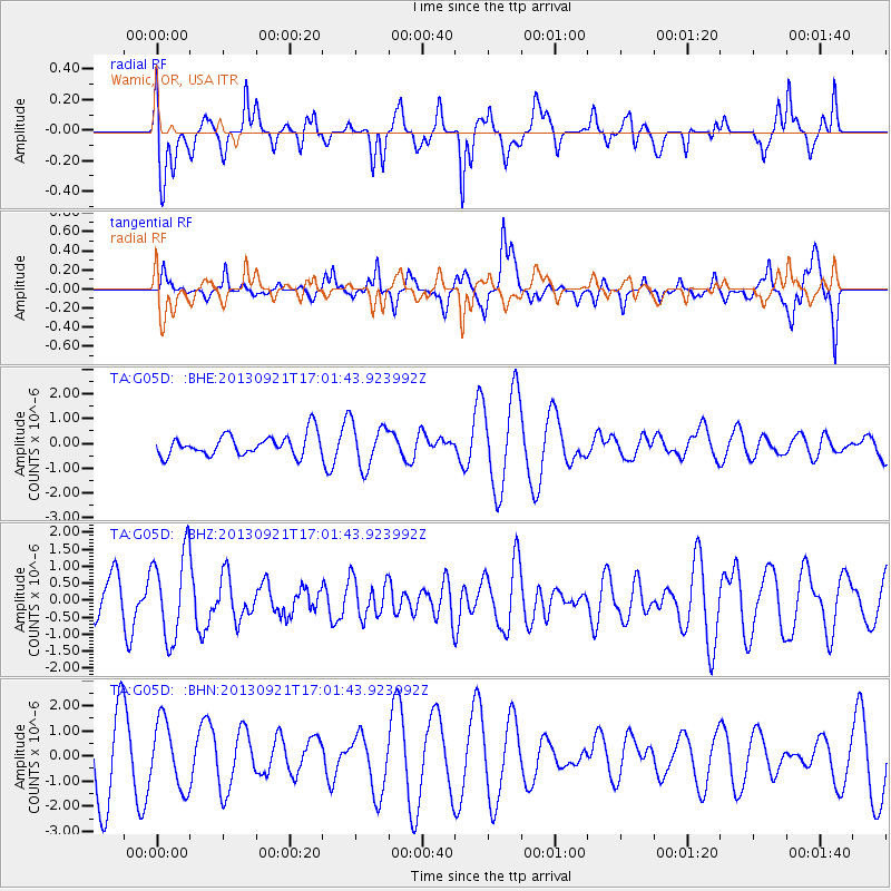
G05D Wamic, OR, USA - Earthquake Result Viewer
*The percent match for this event was below the threshold and hence no stack was calculated.
| Earthquake location: |
South Of Kermadec Islands |
| Earthquake latitude/longitude: |
-33.5/-178.0 |
| Earthquake time(UTC): |
2013/09/21 (264) 16:48:58 GMT |
| Earthquake Depth: |
10 km |
| Earthquake Magnitude: |
5.8 MWW, 5.7 MWC, 5.8 MWW |
| Earthquake Catalog/Contributor: |
NEIC PDE/NEIC COMCAT |
|
| Network: |
TA USArray Transportable Network (new EarthScope stations) |
| Station: |
G05D Wamic, OR, USA |
| Lat/Lon: |
45.24 N/121.32 W |
| Elevation: |
592 m |
|
| Distance: |
93.7 deg |
| Az: |
36.283 deg |
| Baz: |
224.413 deg |
| Ray Param: |
$rayparam |
*The percent match for this event was below the threshold and hence was not used in the summary stack. |
|
| Radial Match: |
57.04648 % |
| Radial Bump: |
400 |
| Transverse Match: |
64.7505 % |
| Transverse Bump: |
400 |
| SOD ConfigId: |
626651 |
| Insert Time: |
2014-04-18 18:45:12.941 +0000 |
| GWidth: |
2.5 |
| Max Bumps: |
400 |
| Tol: |
0.001 |
|
Signal To Noise
| Channel | StoN | STA | LTA |
| TA:G05D: :BHZ:20130921T17:01:43.923992Z | 2.2112765 | 1.263042E-6 | 5.7118234E-7 |
| TA:G05D: :BHN:20130921T17:01:43.923992Z | 0.85224307 | 1.3143887E-6 | 1.5422697E-6 |
| TA:G05D: :BHE:20130921T17:01:43.923992Z | 2.0722663 | 8.718767E-7 | 4.2073586E-7 |
| Arrivals |
| Ps | |
| PpPs | |
| PsPs/PpSs | |


