You are here: Home > Network List > CB - China National Seismic Network Stations List
> Station WHN Wuhantai,Hubei Province > Earthquake Result Viewer
WHN Wuhantai,Hubei Province - Earthquake Result Viewer
| Earthquake location: |
Pakistan |
| Earthquake latitude/longitude: |
27.0/65.5 |
| Earthquake time(UTC): |
2013/09/24 (267) 11:29:47 GMT |
| Earthquake Depth: |
15 km |
| Earthquake Magnitude: |
7.7 MWW, 7.7 MWC, 7.8 MWC |
| Earthquake Catalog/Contributor: |
NEIC PDE/NEIC COMCAT |
|
| Network: |
CB China National Seismic Network |
| Station: |
WHN Wuhantai,Hubei Province |
| Lat/Lon: |
30.54 N/114.35 E |
| Elevation: |
80 m |
|
| Distance: |
42.7 deg |
| Az: |
73.257 deg |
| Baz: |
277.789 deg |
| Ray Param: |
0.07299432 |
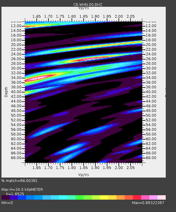
| Estimated Moho Depth: |
34.0 km |
| Estimated Crust Vp/Vs: |
1.65 |
| Assumed Crust Vp: |
6.276 km/s |
| Estimated Crust Vs: |
3.798 km/s |
| Estimated Crust Poisson's Ratio: |
0.21 |
|
| Radial Match: |
96.80391 % |
| Radial Bump: |
400 |
| Transverse Match: |
94.606155 % |
| Transverse Bump: |
400 |
| SOD ConfigId: |
626651 |
| Insert Time: |
2014-04-18 18:58:28.907 +0000 |
| GWidth: |
2.5 |
| Max Bumps: |
400 |
| Tol: |
0.001 |
|

Signal To Noise
| Channel | StoN | STA | LTA |
| CB:WHN:00:BHZ:20130924T11:37:13.45999Z | 12.134894 | 7.646435E-6 | 6.3011953E-7 |
| CB:WHN:00:BHN:20130924T11:37:13.45999Z | 2.6215584 | 1.1396976E-6 | 4.3474049E-7 |
| CB:WHN:00:BHE:20130924T11:37:13.45999Z | 8.323106 | 3.4305838E-6 | 4.1217592E-7 |
| Arrivals |
| Ps | 3.8 SECOND |
| PpPs | 13 SECOND |
| PsPs/PpSs | 17 SECOND |


