You are here: Home > Network List > CB - China National Seismic Network Stations List
> Station XLT Xilinhaote,Neimeng Province > Earthquake Result Viewer
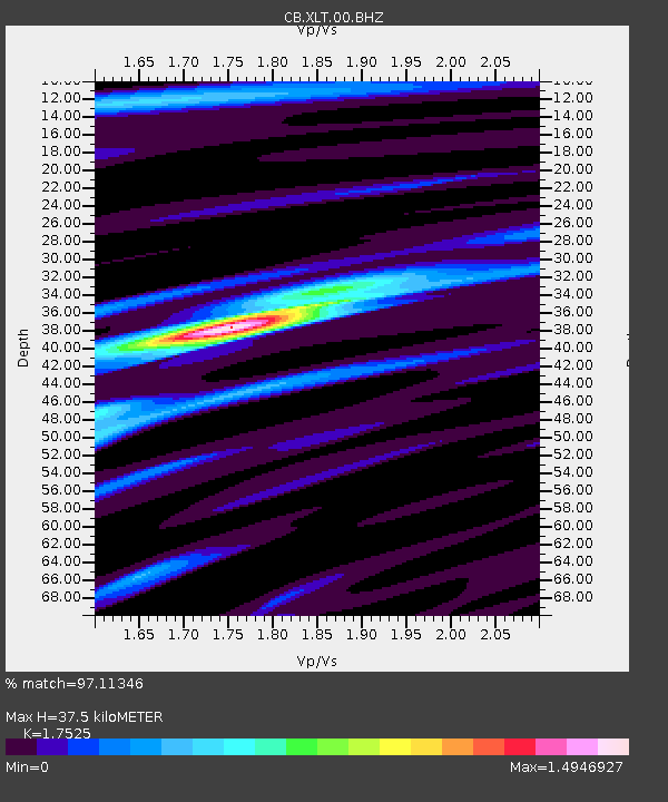
XLT Xilinhaote,Neimeng Province - Earthquake Result Viewer
| Earthquake location: |
Pakistan |
| Earthquake latitude/longitude: |
27.0/65.5 |
| Earthquake time(UTC): |
2013/09/24 (267) 11:29:47 GMT |
| Earthquake Depth: |
15 km |
| Earthquake Magnitude: |
7.7 MWW, 7.7 MWC, 7.8 MWC |
| Earthquake Catalog/Contributor: |
NEIC PDE/NEIC COMCAT |
|
| Network: |
CB China National Seismic Network |
| Station: |
XLT Xilinhaote,Neimeng Province |
| Lat/Lon: |
43.90 N/116.08 E |
| Elevation: |
1030 m |
|
| Distance: |
43.8 deg |
| Az: |
53.724 deg |
| Baz: |
264.55 deg |
| Ray Param: |
0.07227578 |
| Estimated Moho Depth: |
37.5 km |
| Estimated Crust Vp/Vs: |
1.75 |
| Assumed Crust Vp: |
6.459 km/s |
| Estimated Crust Vs: |
3.686 km/s |
| Estimated Crust Poisson's Ratio: |
0.26 |
|
| Radial Match: |
97.11346 % |
| Radial Bump: |
278 |
| Transverse Match: |
89.51466 % |
| Transverse Bump: |
400 |
| SOD ConfigId: |
626651 |
| Insert Time: |
2014-04-18 18:58:31.694 +0000 |
| GWidth: |
2.5 |
| Max Bumps: |
400 |
| Tol: |
0.001 |
|

Signal To Noise
| Channel | StoN | STA | LTA |
| CB:XLT:00:BHZ:20130924T11:37:22.489989Z | 13.696879 | 6.381194E-6 | 4.658867E-7 |
| CB:XLT:00:BHN:20130924T11:37:22.489989Z | 2.4377332 | 2.941878E-7 | 1.2068088E-7 |
| CB:XLT:00:BHE:20130924T11:37:22.489989Z | 9.920755 | 3.358185E-6 | 3.3850094E-7 |
| Arrivals |
| Ps | 4.7 SECOND |
| PpPs | 15 SECOND |
| PsPs/PpSs | 20 SECOND |


