You are here: Home > Network List > CN - Canadian National Seismograph Network Stations List
> Station VIMO VICTOR MINE, ON > Earthquake Result Viewer
VIMO VICTOR MINE, ON - Earthquake Result Viewer
| Earthquake location: |
Pakistan |
| Earthquake latitude/longitude: |
27.0/65.5 |
| Earthquake time(UTC): |
2013/09/24 (267) 11:29:47 GMT |
| Earthquake Depth: |
15 km |
| Earthquake Magnitude: |
7.7 MWW, 7.7 MWC, 7.8 MWC |
| Earthquake Catalog/Contributor: |
NEIC PDE/NEIC COMCAT |
|
| Network: |
CN Canadian National Seismograph Network |
| Station: |
VIMO VICTOR MINE, ON |
| Lat/Lon: |
52.82 N/83.74 W |
| Elevation: |
78 m |
|
| Distance: |
96.2 deg |
| Az: |
341.81 deg |
| Baz: |
27.329 deg |
| Ray Param: |
0.04058795 |
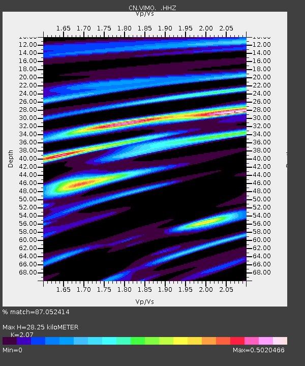
| Estimated Moho Depth: |
28.25 km |
| Estimated Crust Vp/Vs: |
2.07 |
| Assumed Crust Vp: |
6.459 km/s |
| Estimated Crust Vs: |
3.121 km/s |
| Estimated Crust Poisson's Ratio: |
0.35 |
|
| Radial Match: |
87.052414 % |
| Radial Bump: |
270 |
| Transverse Match: |
62.10546 % |
| Transverse Bump: |
400 |
| SOD ConfigId: |
626651 |
| Insert Time: |
2014-04-18 18:59:16.915 +0000 |
| GWidth: |
2.5 |
| Max Bumps: |
400 |
| Tol: |
0.001 |
|

Signal To Noise
| Channel | StoN | STA | LTA |
| CN:VIMO: :HHZ:20130924T11:42:43.360015Z | 2.4716766 | 4.1252736E-7 | 1.6690184E-7 |
| CN:VIMO: :HHN:20130924T11:42:43.360015Z | 1.7862552 | 2.2388934E-7 | 1.2534007E-7 |
| CN:VIMO: :HHE:20130924T11:42:43.360015Z | 1.8295337 | 1.740994E-7 | 9.516053E-8 |
| Arrivals |
| Ps | 4.8 SECOND |
| PpPs | 13 SECOND |
| PsPs/PpSs | 18 SECOND |


