You are here: Home > Network List > G - GEOSCOPE Stations List
> Station RER Riviere de l'Est, La Reunion (Indian Ocean) > Earthquake Result Viewer
RER Riviere de l'Est, La Reunion (Indian Ocean) - Earthquake Result Viewer
| Earthquake location: |
Pakistan |
| Earthquake latitude/longitude: |
27.0/65.5 |
| Earthquake time(UTC): |
2013/09/24 (267) 11:29:47 GMT |
| Earthquake Depth: |
15 km |
| Earthquake Magnitude: |
7.7 MWW, 7.7 MWC, 7.8 MWC |
| Earthquake Catalog/Contributor: |
NEIC PDE/NEIC COMCAT |
|
| Network: |
G GEOSCOPE |
| Station: |
RER Riviere de l'Est, La Reunion (Indian Ocean) |
| Lat/Lon: |
21.16 S/55.75 E |
| Elevation: |
834 m |
|
| Distance: |
48.8 deg |
| Az: |
192.143 deg |
| Baz: |
11.605 deg |
| Ray Param: |
0.06914025 |
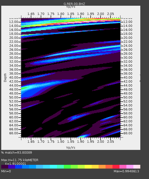
| Estimated Moho Depth: |
11.75 km |
| Estimated Crust Vp/Vs: |
1.91 |
| Assumed Crust Vp: |
4.73 km/s |
| Estimated Crust Vs: |
2.476 km/s |
| Estimated Crust Poisson's Ratio: |
0.31 |
|
| Radial Match: |
93.80089 % |
| Radial Bump: |
283 |
| Transverse Match: |
76.00528 % |
| Transverse Bump: |
400 |
| SOD ConfigId: |
626651 |
| Insert Time: |
2014-04-18 19:00:09.928 +0000 |
| GWidth: |
2.5 |
| Max Bumps: |
400 |
| Tol: |
0.001 |
|

Signal To Noise
| Channel | StoN | STA | LTA |
| G:RER:00:BHZ:20130924T11:38:01.149993Z | 3.0111809 | 9.7997545E-6 | 3.2544556E-6 |
| G:RER:00:BHN:20130924T11:38:01.149993Z | 2.8143735 | 5.556203E-6 | 1.9742238E-6 |
| G:RER:00:BHE:20130924T11:38:01.149993Z | 0.8714623 | 2.4391804E-6 | 2.7989513E-6 |
| Arrivals |
| Ps | 2.3 SECOND |
| PpPs | 7.0 SECOND |
| PsPs/PpSs | 9.3 SECOND |


