You are here: Home > Network List > G - GEOSCOPE Stations List
> Station TAM Tamanrasset, Algeria > Earthquake Result Viewer
TAM Tamanrasset, Algeria - Earthquake Result Viewer

| Earthquake location: |
Pakistan |
| Earthquake latitude/longitude: |
27.0/65.5 |
| Earthquake time(UTC): |
2013/09/24 (267) 11:29:47 GMT |
| Earthquake Depth: |
15 km |
| Earthquake Magnitude: |
7.7 MWW, 7.7 MWC, 7.8 MWC |
| Earthquake Catalog/Contributor: |
NEIC PDE/NEIC COMCAT |
|
| Network: |
G GEOSCOPE |
| Station: |
TAM Tamanrasset, Algeria |
| Lat/Lon: |
22.79 N/5.53 E |
| Elevation: |
1377 m |
|
| Distance: |
54.1 deg |
| Az: |
279.634 deg |
| Baz: |
72.478 deg |
| Ray Param: |
0.06562374 |
| Estimated Moho Depth: |
39.25 km |
| Estimated Crust Vp/Vs: |
1.66 |
| Assumed Crust Vp: |
6.61 km/s |
| Estimated Crust Vs: |
3.976 km/s |
| Estimated Crust Poisson's Ratio: |
0.22 |
|
| Radial Match: |
99.13039 % |
| Radial Bump: |
255 |
| Transverse Match: |
94.37638 % |
| Transverse Bump: |
400 |
| SOD ConfigId: |
626651 |
| Insert Time: |
2014-04-18 19:00:13.653 +0000 |
| GWidth: |
2.5 |
| Max Bumps: |
400 |
| Tol: |
0.001 |
|
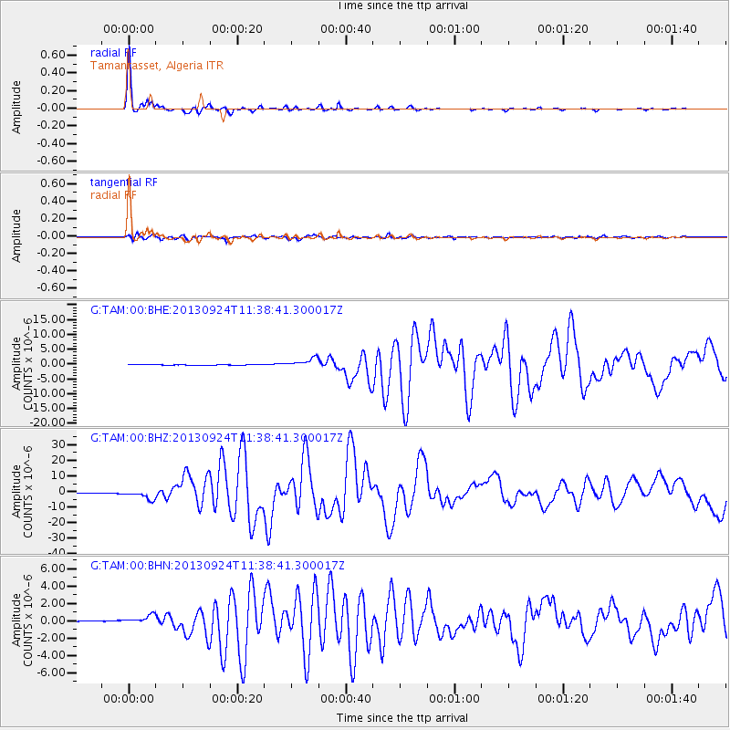
Signal To Noise
| Channel | StoN | STA | LTA |
| G:TAM:00:BHZ:20130924T11:38:41.300017Z | 24.76883 | 3.069682E-6 | 1.2393326E-7 |
| G:TAM:00:BHN:20130924T11:38:41.300017Z | 7.3914757 | 4.8639055E-7 | 6.580425E-8 |
| G:TAM:00:BHE:20130924T11:38:41.300017Z | 15.457569 | 1.5337597E-6 | 9.922387E-8 |
| Arrivals |
| Ps | 4.2 SECOND |
| PpPs | 15 SECOND |
| PsPs/PpSs | 19 SECOND |


