You are here: Home > Network List > II - Global Seismograph Network (GSN - IRIS/IDA) Stations List
> Station KAPI Kappang, Sulawesi, Indonesia > Earthquake Result Viewer
KAPI Kappang, Sulawesi, Indonesia - Earthquake Result Viewer

| Earthquake location: |
Pakistan |
| Earthquake latitude/longitude: |
27.0/65.5 |
| Earthquake time(UTC): |
2013/09/24 (267) 11:29:47 GMT |
| Earthquake Depth: |
15 km |
| Earthquake Magnitude: |
7.7 MWW, 7.7 MWC, 7.8 MWC |
| Earthquake Catalog/Contributor: |
NEIC PDE/NEIC COMCAT |
|
| Network: |
II Global Seismograph Network (GSN - IRIS/IDA) |
| Station: |
KAPI Kappang, Sulawesi, Indonesia |
| Lat/Lon: |
5.01 S/119.75 E |
| Elevation: |
300 m |
|
| Distance: |
61.3 deg |
| Az: |
112.801 deg |
| Baz: |
304.311 deg |
| Ray Param: |
0.060958486 |
| Estimated Moho Depth: |
50.75 km |
| Estimated Crust Vp/Vs: |
1.65 |
| Assumed Crust Vp: |
6.343 km/s |
| Estimated Crust Vs: |
3.85 km/s |
| Estimated Crust Poisson's Ratio: |
0.21 |
|
| Radial Match: |
95.91202 % |
| Radial Bump: |
350 |
| Transverse Match: |
90.13205 % |
| Transverse Bump: |
400 |
| SOD ConfigId: |
626651 |
| Insert Time: |
2014-04-18 19:04:20.738 +0000 |
| GWidth: |
2.5 |
| Max Bumps: |
400 |
| Tol: |
0.001 |
|
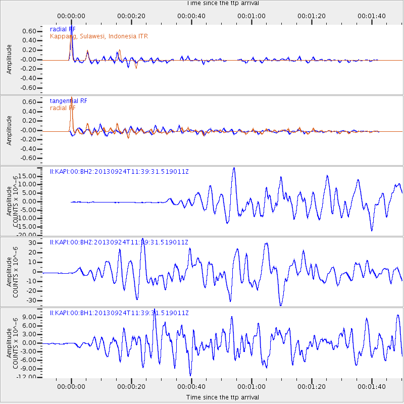
Signal To Noise
| Channel | StoN | STA | LTA |
| II:KAPI:00:BHZ:20130924T11:39:31.519011Z | 13.064381 | 2.2718748E-6 | 1.738984E-7 |
| II:KAPI:00:BH1:20130924T11:39:31.519011Z | 4.2161293 | 5.655883E-7 | 1.341487E-7 |
| II:KAPI:00:BH2:20130924T11:39:31.519011Z | 8.179451 | 1.0048501E-6 | 1.2285057E-7 |
| Arrivals |
| Ps | 5.4 SECOND |
| PpPs | 20 SECOND |
| PsPs/PpSs | 26 SECOND |


