You are here: Home > Network List > TA - USArray Transportable Network (new EarthScope stations) Stations List
> Station G59A Clarenceville, QC, USA > Earthquake Result Viewer
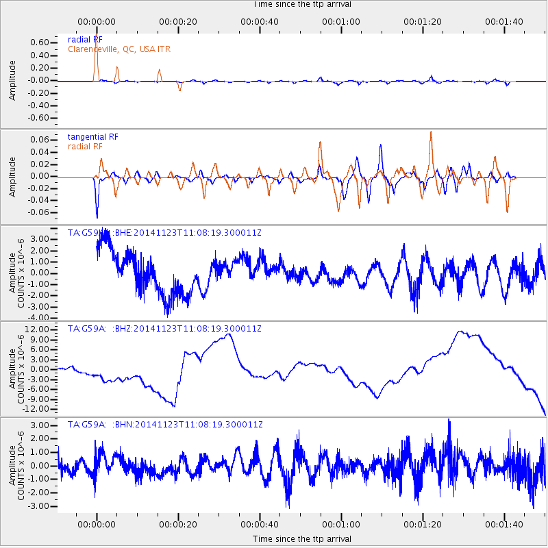
G59A Clarenceville, QC, USA - Earthquake Result Viewer
*The percent match for this event was below the threshold and hence no stack was calculated.
| Earthquake location: |
Off Coast Of Oregon |
| Earthquake latitude/longitude: |
43.8/-128.5 |
| Earthquake time(UTC): |
2014/11/23 (327) 11:01:25 GMT |
| Earthquake Depth: |
14 km |
| Earthquake Magnitude: |
5.2 MW, 5.3 mb, 4.7 MS |
| Earthquake Catalog/Contributor: |
ISC/ISC |
|
| Network: |
TA USArray Transportable Network (new EarthScope stations) |
| Station: |
G59A Clarenceville, QC, USA |
| Lat/Lon: |
45.08 N/73.18 W |
| Elevation: |
36 m |
|
| Distance: |
38.9 deg |
| Az: |
68.215 deg |
| Baz: |
288.436 deg |
| Ray Param: |
$rayparam |
*The percent match for this event was below the threshold and hence was not used in the summary stack. |
|
| Radial Match: |
59.039898 % |
| Radial Bump: |
400 |
| Transverse Match: |
47.89795 % |
| Transverse Bump: |
400 |
| SOD ConfigId: |
3390531 |
| Insert Time: |
2019-04-15 04:31:33.306 +0000 |
| GWidth: |
2.5 |
| Max Bumps: |
400 |
| Tol: |
0.001 |
|
Signal To Noise
| Channel | StoN | STA | LTA |
| TA:G59A: :BHZ:20141123T11:08:19.300011Z | 1.4907011 | 2.7962694E-6 | 1.8758083E-6 |
| TA:G59A: :BHN:20141123T11:08:19.300011Z | 0.8439947 | 1.1014158E-6 | 1.3050033E-6 |
| TA:G59A: :BHE:20141123T11:08:19.300011Z | 0.4617398 | 8.830823E-7 | 1.9125107E-6 |
| Arrivals |
| Ps | |
| PpPs | |
| PsPs/PpSs | |


