You are here: Home > Network List > TA - USArray Transportable Network (new EarthScope stations) Stations List
> Station D58A Chemin du LacGrosbois, Trois-Rives, QC, CAN > Earthquake Result Viewer
D58A Chemin du LacGrosbois, Trois-Rives, QC, CAN - Earthquake Result Viewer
| Earthquake location: |
Pakistan |
| Earthquake latitude/longitude: |
27.0/65.5 |
| Earthquake time(UTC): |
2013/09/24 (267) 11:29:47 GMT |
| Earthquake Depth: |
15 km |
| Earthquake Magnitude: |
7.7 MWW, 7.7 MWC, 7.8 MWC |
| Earthquake Catalog/Contributor: |
NEIC PDE/NEIC COMCAT |
|
| Network: |
TA USArray Transportable Network (new EarthScope stations) |
| Station: |
D58A Chemin du LacGrosbois, Trois-Rives, QC, CAN |
| Lat/Lon: |
47.10 N/72.88 W |
| Elevation: |
398 m |
|
| Distance: |
97.3 deg |
| Az: |
332.777 deg |
| Baz: |
36.701 deg |
| Ray Param: |
0.040258013 |
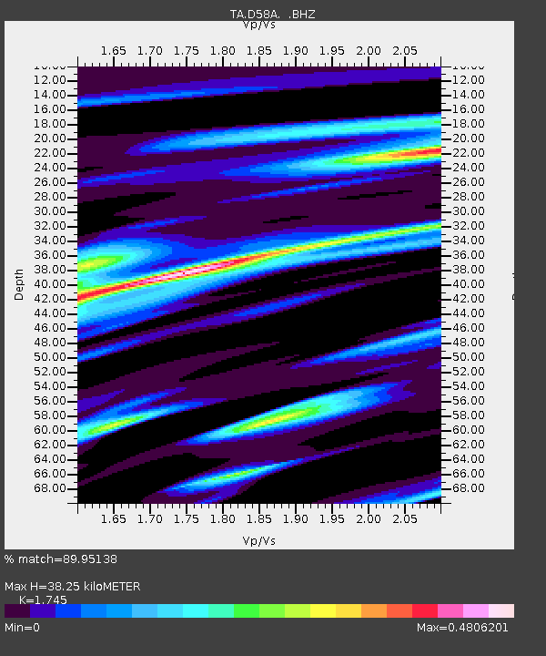
| Estimated Moho Depth: |
38.25 km |
| Estimated Crust Vp/Vs: |
1.75 |
| Assumed Crust Vp: |
6.61 km/s |
| Estimated Crust Vs: |
3.788 km/s |
| Estimated Crust Poisson's Ratio: |
0.26 |
|
| Radial Match: |
89.95138 % |
| Radial Bump: |
400 |
| Transverse Match: |
78.18488 % |
| Transverse Bump: |
400 |
| SOD ConfigId: |
626651 |
| Insert Time: |
2014-04-18 19:09:10.968 +0000 |
| GWidth: |
2.5 |
| Max Bumps: |
400 |
| Tol: |
0.001 |
|
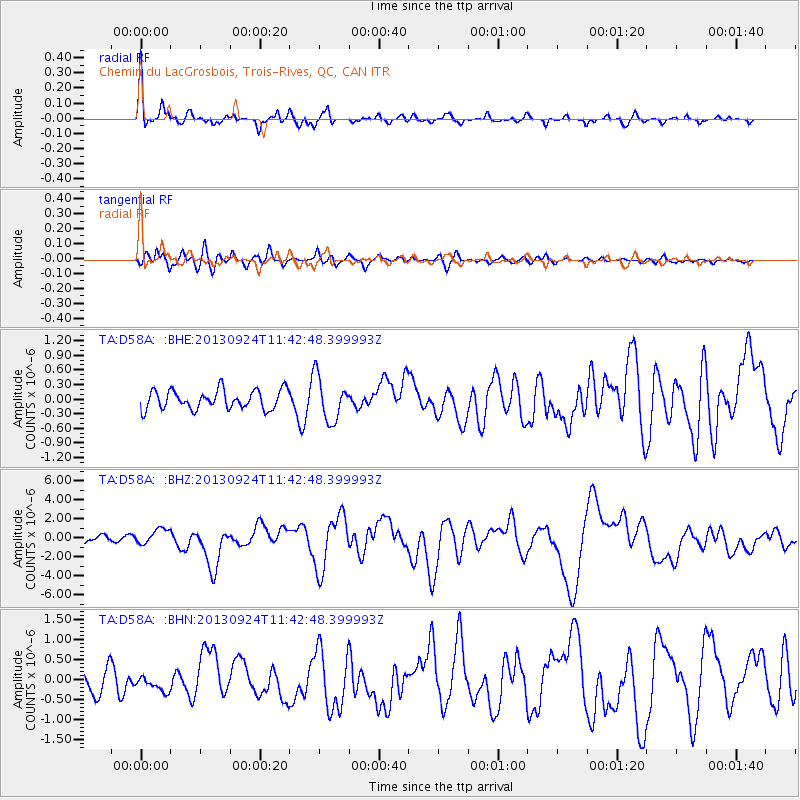
Signal To Noise
| Channel | StoN | STA | LTA |
| TA:D58A: :BHZ:20130924T11:42:48.399993Z | 2.1103475 | 8.2011513E-7 | 3.8861617E-7 |
| TA:D58A: :BHN:20130924T11:42:48.399993Z | 0.4408809 | 1.8966126E-7 | 4.301871E-7 |
| TA:D58A: :BHE:20130924T11:42:48.399993Z | 2.2886207 | 4.4786387E-7 | 1.956916E-7 |
| Arrivals |
| Ps | 4.4 SECOND |
| PpPs | 16 SECOND |
| PsPs/PpSs | 20 SECOND |


