You are here: Home > Network List > IU - Global Seismograph Network (GSN - IRIS/USGS) Stations List
> Station FURI Mt. Furi, Ethiopia > Earthquake Result Viewer
FURI Mt. Furi, Ethiopia - Earthquake Result Viewer
*The percent match for this event was below the threshold and hence no stack was calculated.
| Earthquake location: |
Pakistan |
| Earthquake latitude/longitude: |
27.2/65.6 |
| Earthquake time(UTC): |
2013/09/24 (267) 11:36:27 GMT |
| Earthquake Depth: |
10 km |
| Earthquake Magnitude: |
5.8 MB |
| Earthquake Catalog/Contributor: |
NEIC PDE/NEIC COMCAT |
|
| Network: |
IU Global Seismograph Network (GSN - IRIS/USGS) |
| Station: |
FURI Mt. Furi, Ethiopia |
| Lat/Lon: |
8.90 N/38.68 E |
| Elevation: |
2570 m |
|
| Distance: |
31.3 deg |
| Az: |
239.425 deg |
| Baz: |
50.894 deg |
| Ray Param: |
$rayparam |
*The percent match for this event was below the threshold and hence was not used in the summary stack. |
|
| Radial Match: |
53.13039 % |
| Radial Bump: |
400 |
| Transverse Match: |
71.386856 % |
| Transverse Bump: |
400 |
| SOD ConfigId: |
626651 |
| Insert Time: |
2014-04-18 19:14:27.184 +0000 |
| GWidth: |
2.5 |
| Max Bumps: |
400 |
| Tol: |
0.001 |
|
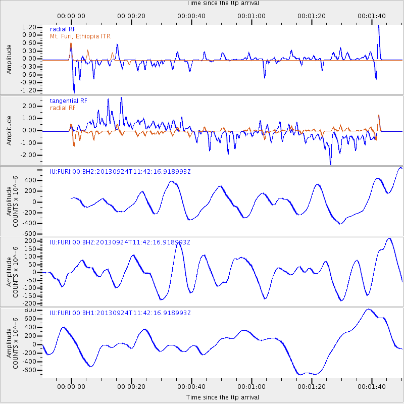
Signal To Noise
| Channel | StoN | STA | LTA |
| IU:FURI:00:BHZ:20130924T11:42:16.918993Z | 1.4487699 | 4.792693E-5 | 3.308112E-5 |
| IU:FURI:00:BH1:20130924T11:42:16.918993Z | 1.7535405 | 2.1729206E-4 | 1.239162E-4 |
| IU:FURI:00:BH2:20130924T11:42:16.918993Z | 2.9802625 | 2.9441863E-4 | 9.878949E-5 |
| Arrivals |
| Ps | |
| PpPs | |
| PsPs/PpSs | |


